IMAGES TAKEN NEAR TO
Sowerby Croft Lane, SOWERBY BRIDGE, HX6 3QD
Introduction
This page details the photographs taken nearby to Sowerby Croft Lane, HX6 3QD by members of the Geograph project.
The Geograph project started in 2005 with the aim of publishing, organising and preserving representative images for every square kilometre of Great Britain, Ireland and the Isle of Man.

There are currently over 7.5m images from over14,400 individuals and you can help contribute to the project by visiting https://www.geograph.org.uk
Image Map
Images are licensed for reuse under creativecommons.org/licenses/by-sa/2.0
Notes
- Clicking on the map will re-center to the selected point.
- The higher the marker number, the further away the image location is from the centre of the postcode.
Image Listing (159 Images Found)
Images are licensed for reuse under creativecommons.org/licenses/by-sa/2.0
Image
Details
Distance
1
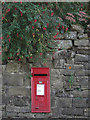
Postbox on Long Lane
Near the Scar Head Road junction.
Image: © michael ely
Taken: 28 Sep 2008
0.03 miles
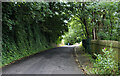
2
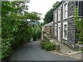
Scar Head Road, Sowerby Bridge
Here there is a long retaining wall, and a length of road that is wider opposite a part of the wall that is clear of ivy and has perhaps been rebuilt during the last few decades.
Image: © Humphrey Bolton
Taken: 14 Jun 2012
0.03 miles
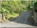
4
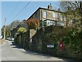
Junction of Scar Head Lane and Sowerby Croft Road
Note a postbox in the wall to the right.
Image: © Stephen Craven
Taken: 24 Apr 2021
0.03 miles
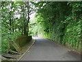
5
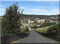
Boggart Lane, Sowerby Bridge
Looking back (north) towards Sowerby Bridge. This is a very steep hill that climbs out of the town from the Station Road/Norland Road junction.
Image: © michael ely
Taken: 28 Sep 2008
0.04 miles
6
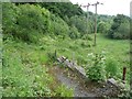
Land off Scarr Head Road, Norland
This strip of land is over a disused railway tunnel.
Image: © Humphrey Bolton
Taken: 14 Jun 2012
0.04 miles
7
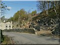
Cut stone, Scar Head Road
There was already a scar here (either natural, or the result of quarrying) but it appears to have been cut further back recently to give access for the construction of a new property.
Image: © Stephen Craven
Taken: 24 Apr 2021
0.05 miles
8
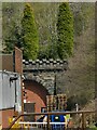
Scar Head Tunnel, southern portal
The tunnel was on the Sowerby Bridge to Rishworth railway branch line, opened in 1878 and closed in 1958. The southern portal can just be glimpsed behind a modern factory, see Image for context.
Image: © Stephen Craven
Taken: 24 Apr 2021
0.06 miles
9
Houses, Scarr Head Road, Norland
The nearer house is called Albion House.
Image: © Humphrey Bolton
Taken: 14 Jun 2012
0.06 miles
10
Sowerby Bridge FP78 at Long Lane, Sowerby Bridge
The bottom end of the path is on a driveway, There is a signpost. The old boundary between Sowerby Bridge and Norland goes up the wall on the western side of the footpath.
Image: © Humphrey Bolton
Taken: 22 Aug 2015
0.07 miles