IMAGES TAKEN NEAR TO
Rough Hey Wood, SOWERBY BRIDGE, HX6 3NB
Introduction
This page details the photographs taken nearby to Rough Hey Wood, HX6 3NB by members of the Geograph project.
The Geograph project started in 2005 with the aim of publishing, organising and preserving representative images for every square kilometre of Great Britain, Ireland and the Isle of Man.

There are currently over 7.5m images from over14,400 individuals and you can help contribute to the project by visiting https://www.geograph.org.uk
Image Map
Images are licensed for reuse under creativecommons.org/licenses/by-sa/2.0
Notes
- Clicking on the map will re-center to the selected point.
- The higher the marker number, the further away the image location is from the centre of the postcode.
Image Listing (82 Images Found)
Images are licensed for reuse under creativecommons.org/licenses/by-sa/2.0
Image
Details
Distance
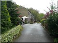
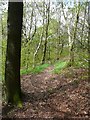
2
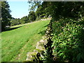
Sowerby Bridge FP135 behind Rough Hey
There appears to have been some landscaping here, and all trace of the path has gone. There are young saplings growing, which will eventually screen the houses from the wood. This part of the lower loop of FP135 is out of use, as people have followed the contour from the top of Rough Hey Scar and beaten a path to join the main line of FP135.
Image: © Humphrey Bolton
Taken: 21 Jun 2012
0.02 miles
3
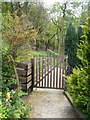
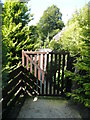
Gate on Sowerby Bridge Footpath 134 at Rough Hey, Norland
Image: © Humphrey Bolton
Taken: 10 May 2012
0.02 miles
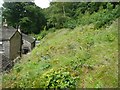
4
Sowerby Bridge FP135 approaching the rear of Rough Hey
This is the lower loop of the path, and it would seem likely that in the distant past it went to Rough Hey when it was a farm from this direction of from the south, where it is a shallowly sunken track sloping down through the wood.
Image: © Humphrey Bolton
Taken: 21 Jun 2012
0.04 miles
5
Gate on Sowerby Bridge FP134 at Rough Hey
Image: © Humphrey Bolton
Taken: 6 Sep 2015
0.04 miles
6
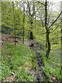
Sowerby Bridge Footpath 135 in Rough Hey Wood, Norland
This wood is mainly beech trees, with pale green leaves in Spring.
Image: © Humphrey Bolton
Taken: 10 May 2012
0.04 miles
7
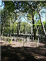
Replanting in Rough Hey Wood, Norland
Image: © Humphrey Bolton
Taken: 6 Sep 2015
0.07 miles
8
Sowerby Bridge FP134, Norland
This path, along the edge of Rough Hey Wood, has been infested with Himalayan Balsam. However it was not too difficult to force my way through. Fortunately this plant does not sting or scratch! (I have read that it is edible, but don't intend to test this.)
Image: © Humphrey Bolton
Taken: 6 Sep 2015
0.07 miles
9
Sowerby Bridge Footpath 135 approaching Stansfield Mill Lane
Image: © Humphrey Bolton
Taken: 10 May 2012
0.08 miles
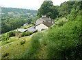
10
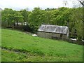
Station House, Norland
Seen from the driveway to Rough Hey. The station was called Triangle after the nearby industrial hamlet, and was closed to passengers in the 1920s. It was on a branch line from Sowerby Bridge to Rippondon and Rishworth built by the Lancashire and Yorkshire Railway in 1878. By 1955 it was only open to Ripponden for goods traffic, and closed completely in the 1960s.
Image: © Humphrey Bolton
Taken: 10 May 2012
0.08 miles