IMAGES TAKEN NEAR TO
SOWERBY BRIDGE, HX6 3LL
Introduction
This page details the photographs taken nearby to HX6 3LL by members of the Geograph project.
The Geograph project started in 2005 with the aim of publishing, organising and preserving representative images for every square kilometre of Great Britain, Ireland and the Isle of Man.

There are currently over 7.5m images from over14,400 individuals and you can help contribute to the project by visiting https://www.geograph.org.uk
Image Map
Images are licensed for reuse under creativecommons.org/licenses/by-sa/2.0
Notes
- Clicking on the map will re-center to the selected point.
- The higher the marker number, the further away the image location is from the centre of the postcode.
Image Listing (155 Images Found)
Images are licensed for reuse under creativecommons.org/licenses/by-sa/2.0
Image
Details
Distance
1
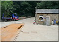
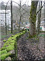
Footpath crossing a factory yard, Norland
This is on the footpath from Long Lane, Norland, to Rochdale Road, Sowerby. It continues up the driveway.
Image: © Humphrey Bolton
Taken: 23 Aug 2015
0.01 miles
2
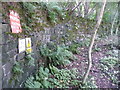
Signs where the footpath enters the factory yard
Image: © Humphrey Bolton
Taken: 23 Aug 2015
0.03 miles
3
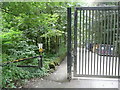
Footpath passing gate on driveway to the recycling centre, Sowerby
This is where the footpath leaves Rochdale road on its way to Long Lane, Norland.
Image: © Humphrey Bolton
Taken: 23 Aug 2015
0.04 miles
4
Sowerby Bridge FP94
This is the footpath as it leaves the bridge over the disused railway towards the River Ryburn.
Image: © Humphrey Bolton
Taken: 8 Apr 2014
0.04 miles
5
The footpath to Haugh End Lane at Rochdale Road, Sowerby
There is no signpost for the footpath.
Image: © Humphrey Bolton
Taken: 23 Aug 2015
0.05 miles
6
Gas installation on the disused railway
There is a path along the left side, but it only leads to a locked gate.
Image: © Humphrey Bolton
Taken: 8 Apr 2014
0.05 miles
7
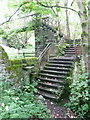
Steps up to footbridge over the disused railway, Norland
Image: © Humphrey Bolton
Taken: 23 Aug 2015
0.05 miles
8

Old milestone
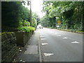
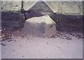
On the south side of the A58 at the west end of Sowerby Bridge, the top of the milestone just shows above tarmac pavement level. There is extensive old damage to the top. The inscribed legends which are mostly below the pavement would have been To Rochdale 13 Miles and To Halifax 3 Miles. The 21½ mile long Rochdale, Halifax and Ealand turnpike was first enacted in 1734 so the stones along this route probably date from the late 18C. This stone is not 'listed'
Image: © Robert Glover
Taken: 14 Nov 2020
0.05 miles
9
Old Milestone, on the A58, W end of Sowerby Bridge
Opposite Stonegarth. Located on the South side of road, Set in tarmac, on narrow verge 20m from 30mph Town sign. Carved stone post, 18th century.
Inscription reads: TO / ROCHDALE / (13 / MILES) // TO / HALIFAX / (3 / MILES)
Milestone Society National ID: YW_HARO03
Image: © Christine Minto
Taken: 31 Jan 2006
0.05 miles