IMAGES TAKEN NEAR TO
Holmes Road, SOWERBY BRIDGE, HX6 3LF
Introduction
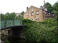
This page details the photographs taken nearby to Holmes Road, HX6 3LF by members of the Geograph project.
The Geograph project started in 2005 with the aim of publishing, organising and preserving representative images for every square kilometre of Great Britain, Ireland and the Isle of Man.

There are currently over 7.5m images from over14,400 individuals and you can help contribute to the project by visiting https://www.geograph.org.uk
Image Map
Images are licensed for reuse under creativecommons.org/licenses/by-sa/2.0
Notes
- Clicking on the map will re-center to the selected point.
- The higher the marker number, the further away the image location is from the centre of the postcode.
Image Listing (197 Images Found)
Images are licensed for reuse under creativecommons.org/licenses/by-sa/2.0
Image
Details
Distance
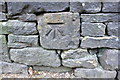
1
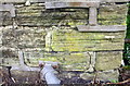
Benchmark on wall at south end of Gas Works Bridge
Ordnance Survey cut mark benchmark described on the Bench Mark Database at www.bench-marks.org.uk/bm48131
Image: © Roger Templeman
Taken: 16 May 2018
0.00 miles
2

Sowerby Bridge - Gasworks Bridge
From the north. For an alternative view, please see Humphrey Bolton's Image
Image: © Dave Bevis
Taken: 19 Feb 2014
0.00 miles
3
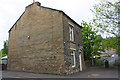
Holmes Cottage at south end of Gas Works Bridge
There is an OS benchmark Image on the far end of the wall between the house and the river bridge, near the lamppost
Image: © Roger Templeman
Taken: 16 May 2018
0.01 miles
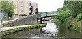
5
Gasworks Bridge, Sowerby Bridge
This is over the River Calder and has an elaborate system of railings to make sure that vehicles do not try to use it and that pedestrians do not fall through the wooden floor at each side.
Image: © Humphrey Bolton
Taken: 22 Apr 2010
0.03 miles
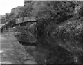
6
The Navigation Inn, Sowerby Bridge
This seems to have been extended from a 17C house (the dark stone to the right). The bridge is called chain bridge because a chain was fixed across the canal here on Sundays to prevent entry to the wharf.
Image: © Humphrey Bolton
Taken: 2 Jul 2006
0.03 miles
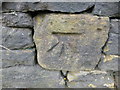
7
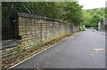
Benchmark on stone in wall on SE side of Holmes Road
Ordnance Survey cut mark benchmark described on the Bench Mark Database at www.bench-marks.org.uk/bm48126
Image: © Roger Templeman
Taken: 16 May 2018
0.06 miles
10
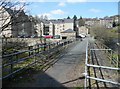
Chapel Lane Bridge over the Calder and Hebble Navigation
Image: © habiloid
Taken: 28 Oct 2016
0.07 miles