IMAGES TAKEN NEAR TO
Holmes Road, SOWERBY BRIDGE, HX6 3LD
Introduction
This page details the photographs taken nearby to Holmes Road, HX6 3LD by members of the Geograph project.
The Geograph project started in 2005 with the aim of publishing, organising and preserving representative images for every square kilometre of Great Britain, Ireland and the Isle of Man.

There are currently over 7.5m images from over14,400 individuals and you can help contribute to the project by visiting https://www.geograph.org.uk
Image Map
Images are licensed for reuse under creativecommons.org/licenses/by-sa/2.0
Notes
- Clicking on the map will re-center to the selected point.
- The higher the marker number, the further away the image location is from the centre of the postcode.
Image Listing (334 Images Found)
Images are licensed for reuse under creativecommons.org/licenses/by-sa/2.0
Image
Details
Distance
1
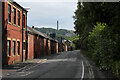
Holmes Lane looking East
Taken from beneath the railway station at Sowerby Bridge. Wainhouse Tower can be seen in the distance - reputedly the tallest folly in the world.
Image: © Chris Heaton
Taken: 15 Aug 2021
0.02 miles
2
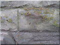
Benchmark on the south side of Holmes Road
Image: © John Slater
Taken: 13 Apr 2013
0.02 miles
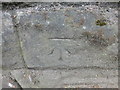
4
Benchmark on stone wall on south side of Holmes Road
Ordnance Survey cut mark benchmark described on the Bench Mark Database at www.bench-marks.org.uk/bm48123
Image: © Roger Templeman
Taken: 16 May 2018
0.02 miles
5
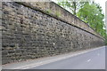
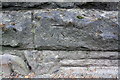
Stone embankment wall on south side of Holmes Road
There is an OS benchmark Image on a stone in the wall about 4ft from the left hand edge of the image
Image: © Roger Templeman
Taken: 16 May 2018
0.02 miles
6
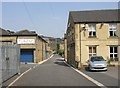
Old Causeway, Sowerby Bridge
This part of the old road through Sowerby Bridge has been widened and surfaced; only the name indicates its origin.
Image: © Humphrey Bolton
Taken: 2 Jul 2006
0.03 miles
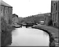
7
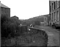
Lock No 2, Rochdale Canal, Sowerby Bridge
Before the restoration, this was taken looking down to Lock No 2 from the blocked bridge under Wharf Street. The building on the right was Lock Hill Mills.
Image: © Dr Neil Clifton
Taken: 20 Aug 1987
0.03 miles
8
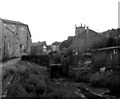
Lock No 2, Rochdale Canal, Sowerby Bridge (2)
This shows the then-derelict Lock No 2 from the bottom end, looking 'uphill'. The bottom gates are missing. Lock Hill Mills on the left, and the tower of Christ Church visible in the right background.
Image: © Dr Neil Clifton
Taken: 20 Aug 1987
0.03 miles
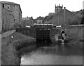
9
Lock No 2, Rochdale Canal, Sowerby Bridge
By 1990 this lock had been rebuilt and restored, but could not be used because the Tuel Lane blockage (behind the photographer) still remained to be dealt with.
Image: © Dr Neil Clifton
Taken: 30 May 1990
0.03 miles
10
Lock No 2, Rochdale Canal, Sowerby Bridge
See also Image By 1990 this lock had been completely rebuilt and restored.
Image: © Dr Neil Clifton
Taken: 30 May 1990
0.03 miles