IMAGES TAKEN NEAR TO
Triangle, SOWERBY BRIDGE, HX6 3HT
Introduction
This page details the photographs taken nearby to HX6 3HT by members of the Geograph project.
The Geograph project started in 2005 with the aim of publishing, organising and preserving representative images for every square kilometre of Great Britain, Ireland and the Isle of Man.

There are currently over 7.5m images from over14,400 individuals and you can help contribute to the project by visiting https://www.geograph.org.uk
Image Map
Images are licensed for reuse under creativecommons.org/licenses/by-sa/2.0
Notes
- Clicking on the map will re-center to the selected point.
- The higher the marker number, the further away the image location is from the centre of the postcode.
Image Listing (66 Images Found)
Images are licensed for reuse under creativecommons.org/licenses/by-sa/2.0
Image
Details
Distance
1
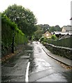
Kebroyd Lane - Halifax Road, Kebroyd
Image: © Betty Longbottom
Taken: 1 Oct 2008
0.08 miles
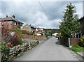
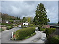
3

Higher Park Royd Drive
This is an unadopted street.
Image: © Humphrey Bolton
Taken: 8 Apr 2014
0.10 miles
5
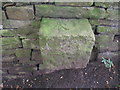
Rivet benchmark by a path off Halifax Road
Image: © John Slater
Taken: 28 Aug 2012
0.11 miles

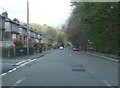
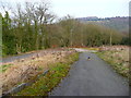
7
Bridleway east of Kebroyd
This seems to be a continuation of Highlee Lane but I can't find it named as such.
Image: © John Slater
Taken: 28 Aug 2012
0.12 miles

9
Kebroyd Mount
This is an unadopted street.
Image: © Humphrey Bolton
Taken: 8 Apr 2014
0.12 miles
10
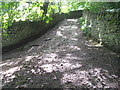
Footpath on former mill driveway, Kebroyd, Ripponden
Image: © Humphrey Bolton
Taken: 13 Mar 2016
0.12 miles