
IMAGES TAKEN NEAR TO
Chapel Lane, SOWERBY BRIDGE, HX6 3FB
Introduction
This page details the photographs taken nearby to Chapel Lane, HX6 3FB by members of the Geograph project.
The Geograph project started in 2005 with the aim of publishing, organising and preserving representative images for every square kilometre of Great Britain, Ireland and the Isle of Man.

There are currently over 7.5m images from over14,400 individuals and you can help contribute to the project by visiting https://www.geograph.org.uk
Image Map
Images are licensed for reuse under creativecommons.org/licenses/by-sa/2.0
Notes
- Clicking on the map will re-center to the selected point.
- The higher the marker number, the further away the image location is from the centre of the postcode.
Image Listing (246 Images Found)
Images are licensed for reuse under creativecommons.org/licenses/by-sa/2.0
Image
Details
Distance
1
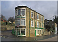
Sowerby Bridge - Veterinary Centre at Bolton Brow
Image: © Dave Bevis
Taken: 19 Feb 2014
0.01 miles
2
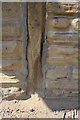
Eroded stonework on #1 Wakefield Road
This is the probable site of an Ordnance Survey cut mark benchmark levelled at 97.423m above Newlyn Datum
Image: © Roger Templeman
Taken: 23 May 2018
0.02 miles
3
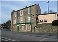
Vet on the corner, Sowerby Bridge
The building is tapered to fit in the fork of the roads to Halifax and Elland.
Image: © Humphrey Bolton
Taken: 5 Mar 2009
0.02 miles
4
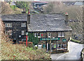
Sowerby Bridge - The Navigation
View down to The Navigation pub from further up Chapel Lane. For alternative views of this pub, please see Image, Image and Image
Image: © Dave Bevis
Taken: 19 Feb 2014
0.02 miles
5
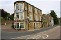
Donaldson's Vets, #1 Wakefield Road at Bolton Road junction
The stonework on the right hand face of the building is badly eroded Image
Image: © Roger Templeman
Taken: 16 May 2018
0.02 miles
6
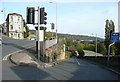
Location of guide post, Bolton Brow
This is the location of the guide post shown in Image The road going downhill on the right is Chapel Lane, and the main road junction is on the left.
Image: © Humphrey Bolton
Taken: 12 Oct 2014
0.02 miles
7

Mile Marker, Rochdale Canal
The Zero mile peg at the junction of the Rochdale Canal and Calder & Hebble Navigation.
Inscription: 0 // Rochdale / Calder & / Hebble // Canal Trust / Rochdale / Canal / 32 miles // Rochdale / Canal / Company
Milestone Society National ID: RCD-00R
Image: © Wendy Biswas
Taken: 1 Jun 2026
0.03 miles
8
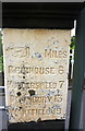
Guide post at junction of Wakefield Road and Chapel Lane
Image: © Roger Templeman
Taken: 16 May 2018
0.03 miles
9
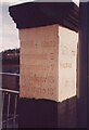
Old Milestone, A58, Bolton Brow, Sowerby Bridge
Located on the South side of road, junction of A6026 (Wakefield Road) traffic lights. 18th/19th century. Alternative views see http://www.geograph.org.uk/photo/4214411 & http://www.geograph.org.uk/photo/4214414
Inscription reads: {hand to left} / MILES / BRIGHOUSE 6 / HUDDERSFIELD 7 / DEWSBURY 13 / WAKEFIELD 19 // {hand to left} / TO / HALIFAX
Milestone Society National ID: YW_XSOWB
Image: © Christine Minto
Taken: 30 Dec 2005
0.03 miles
10
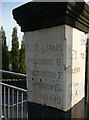
Guide post, Bolton Brow
This is at the junction of the Wakefield Road and the Halifax to Rochdale Road. It is not inscribed on the other side, so was presumably erected at the end of the turnpike road to Wakefield via Salterhebble and Brighouse.
Image: © Humphrey Bolton
Taken: 12 Oct 2014
0.03 miles