IMAGES TAKEN NEAR TO
Triangle, SOWERBY BRIDGE, HX6 3EY
Introduction
This page details the photographs taken nearby to HX6 3EY by members of the Geograph project.
The Geograph project started in 2005 with the aim of publishing, organising and preserving representative images for every square kilometre of Great Britain, Ireland and the Isle of Man.

There are currently over 7.5m images from over14,400 individuals and you can help contribute to the project by visiting https://www.geograph.org.uk
Image Map
Images are licensed for reuse under creativecommons.org/licenses/by-sa/2.0
Notes
- Clicking on the map will re-center to the selected point.
- The higher the marker number, the further away the image location is from the centre of the postcode.
Image Listing (49 Images Found)
Images are licensed for reuse under creativecommons.org/licenses/by-sa/2.0
Image
Details
Distance
1
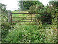
Gate at Kennel lane on the footpath from Shaw's Lane, Sowerby (15)
The gate was tied to a branch with twine, although I think I remember it being easier to open the next time I visited it.
Image: © Humphrey Bolton
Taken: 10 Aug 2015
0.04 miles
2
Footpath from Shaw's Lane at Kennel Lane, Sowerby (14)
This is the gate at the end of the path. Kennel Lane is very narrow here.
Image: © Humphrey Bolton
Taken: 10 Aug 2015
0.04 miles
3

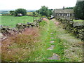
Footpath from Shaw's Lane to Kennel Lane, Sowerby (13)
After turning two corners, the broad grassy track descends to Kennel Lane.
Image: © Humphrey Bolton
Taken: 10 Aug 2015
0.05 miles
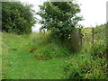
4
Bridleway alongside Clough Bank Lane, Sowerby
This bridleway is probably rarely used; not surprising as it is almost blocked even for walkers at the southern end, and the new part of Clough Bank Lane can be used instead.
Image: © Humphrey Bolton
Taken: 27 Jul 2015
0.07 miles
5
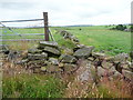
Gate on the bridleway at Clough Bank Lane, Sowerby
The old part of Clough Bank Lane is a bridleway that used to turn west past Lower Clough Banks, and when that route was closed a new track was made to connect with Kennel Lane (see Image and Image However instead of routing the bridleway on this track it seems that a footpath (first shown on the 1893 1:2500 map) was upgraded to a bridleway. However this gate is not suitable for horses.
Image: © Humphrey Bolton
Taken: 27 Jul 2015
0.07 miles
6
Clough Bank Lane, Sowerby
This is the lane southwards from the junction with the footpath from Parkin Hall Lane. Paving stones are showing through the grass. The lane used to turn right past the house (formerly two houses) but has been diverted.
Image: © Humphrey Bolton
Taken: 27 Jul 2015
0.07 miles
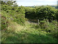
7
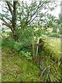
What might be a stile on the Clough Bank Lane bridleway, Sowerby
I did manage to negotiate this (without a horse), but it was not easy.
Image: © Humphrey Bolton
Taken: 27 Jul 2015
0.08 miles
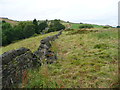
8
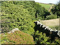
Ruined wall on footpath at Clough Bank Lane, Sowerby
There should be a stile here, but the ruined wall is easy to climb over, The footpath comes from Parkin Hall Lane.
Image: © Humphrey Bolton
Taken: 27 Jul 2015
0.08 miles
9
Sowerby Bridge Bridleway 119
After battling through nettles, thistles and brambles you reach this section of path, which is in a narrow slot hemmed in by bilberry, which overhangs the path so that you have to push your way through.
Image: © Humphrey Bolton
Taken: 10 Aug 2015
0.08 miles
10
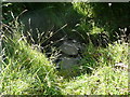
Stepping stones across a stream on Sowerby Bridge Bridleway 119
Image: © Humphrey Bolton
Taken: 10 Aug 2015
0.09 miles