IMAGES TAKEN NEAR TO
Valley Rise, SOWERBY BRIDGE, HX6 3EG
Introduction
This page details the photographs taken nearby to Valley Rise, HX6 3EG by members of the Geograph project.
The Geograph project started in 2005 with the aim of publishing, organising and preserving representative images for every square kilometre of Great Britain, Ireland and the Isle of Man.

There are currently over 7.5m images from over14,400 individuals and you can help contribute to the project by visiting https://www.geograph.org.uk
Image Map
Images are licensed for reuse under creativecommons.org/licenses/by-sa/2.0
Notes
- Clicking on the map will re-center to the selected point.
- The higher the marker number, the further away the image location is from the centre of the postcode.
Image Listing (108 Images Found)
Images are licensed for reuse under creativecommons.org/licenses/by-sa/2.0
Image
Details
Distance
1
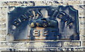
Date stone, 1887, on Bank View
The hand-shake is an interesting motif.
Image: © Humphrey Bolton
Taken: 29 Dec 2013
0.01 miles
2
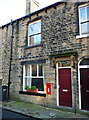
House with Royal Mail letter box, Bank View.Mill Bank
The window is larger than that of the other house of the pair (to the left), and might have been a shop window. The letter box suggests a post office, and the 1978 1:2500 map confirms this. Later maps show that the post office moved to a building further to the east.
Image: © Humphrey Bolton
Taken: 29 Dec 2013
0.02 miles
3
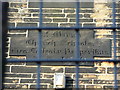
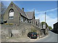
Date stone on St Mary's Primary School, Mill Bank
The security fencing makes it impossible to get a clear view of the inscription on the stone, but my interpretation is: "St Mary's / Church Schools / Deo. Ecclesiæ Pauperibus / A.D. 1850". The latter word suggests to me that the school was founded to educate the children of the poor.
Image: © Humphrey Bolton
Taken: 29 Dec 2013
0.02 miles
4
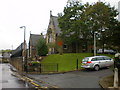
St Mary's CofE (VC) Junior and Infant School
Image: © Alexander P Kapp
Taken: 2 Sep 2009
0.02 miles
5
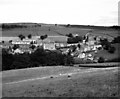
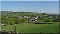
Mill Bank, near Sowerby Bridge, Yorkshire
This fine photograph shows the former handloom weaving village of Mill Bank in an almost unspoiled state. At one time there were many such villages in the Pennines. Sadly, since this photograph, a degree of gentrification has set in, as greedy eyes from Manchester and Leeds have spied money-making possibilities here.
Image: © Dr Neil Clifton
Taken: 20 Aug 1987
0.02 miles
6
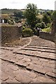
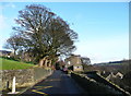
Sett-paved footpath, Mill Bank
Looking south from Mill Bank Road. This sett-paved path leads down to Lower Mill Bank Road.
Image: © Mark Anderson
Taken: 15 Aug 2005
0.02 miles
7
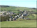
Mill Bank
A hamlet of Sowerby, seen from Ripponden Footpath 55 in Soyland.
Image: © Humphrey Bolton
Taken: 11 Mar 2012
0.02 miles
9
Mill Bank Road, Mill Bank
Here the traffic is slowed by discreet strips of stone setts, much better than the vicious humps found elsewhere.
Image: © Humphrey Bolton
Taken: 29 Dec 2013
0.03 miles
10
On Calderdale Way - view N to Mill Bank near Ripponden
Image: © Colin Park
Taken: 7 May 2018
0.03 miles