IMAGES TAKEN NEAR TO
Sandy Dyke Lane, SOWERBY BRIDGE, HX6 3DS
Introduction
This page details the photographs taken nearby to Sandy Dyke Lane, HX6 3DS by members of the Geograph project.
The Geograph project started in 2005 with the aim of publishing, organising and preserving representative images for every square kilometre of Great Britain, Ireland and the Isle of Man.

There are currently over 7.5m images from over14,400 individuals and you can help contribute to the project by visiting https://www.geograph.org.uk
Image Map
Images are licensed for reuse under creativecommons.org/licenses/by-sa/2.0
Notes
- Clicking on the map will re-center to the selected point.
- The higher the marker number, the further away the image location is from the centre of the postcode.
Image Listing (70 Images Found)
Images are licensed for reuse under creativecommons.org/licenses/by-sa/2.0
Image
Details
Distance
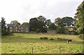
1
Highland laddie, Rochdale Road, Sowerby
Used to being photographed, and does not think much of my camera.
Image: © Humphrey Bolton
Taken: 20 Sep 2007
0.02 miles
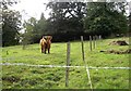
2
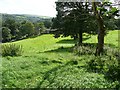
House, field and bull, Rochdale Road, Sowerby
This young bull has the field to himself.
Image: © Humphrey Bolton
Taken: 20 Sep 2007
0.02 miles
3
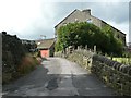
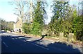
Sandy Dyke Lane, Triangle, Sowerby
Seen from the top of Stubbing Lane.
Image: © Humphrey Bolton
Taken: 16 Aug 2012
0.05 miles
4
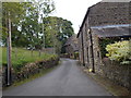
Sowerby Bridge FP133 off Oak Lane southwards
Image: © Humphrey Bolton
Taken: 16 Aug 2012
0.06 miles
5
Sowerby Bridge FP133 off Oak Lane northwards
The path passes through the farmyard of Lower Deer Play.
Image: © Humphrey Bolton
Taken: 16 Aug 2012
0.06 miles
6
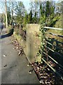
A gatepost of the former Church of St John the Divine, Rochdale Road, Triangle
This church was built for Frederick Edward Rawson and designed by W. S. Barber for a congregation of 300. It cost £7,000. It was consecrated on 23rd September 1880, the year after Rawson's death. It was one of the first churches to be constructed with reinforced concrete.
In 1882, schools for 200 children were built to the north of the church.
The church and the windows were severely damaged by fire in 1917. It was restored, but was closed in 1968, and the building was demolished in 1973. The font was moved to Saint George's Church, Sowerby. (Malcolm Bull)
Image: © Humphrey Bolton
Taken: 5 Nov 2012
0.06 miles
7
Sandy Dyke Lane - viewed from Dean Lane
Image: © Betty Longbottom
Taken: 8 Jun 2015
0.06 miles
8
Gateway to the former Sunday School behind the Church of St John the Divine, Rochdale Road, Triangle
The church was consecrated in 1880 and the Sunday Schoolbuilt in 1882. See Image
Image: © Humphrey Bolton
Taken: 5 Nov 2012
0.07 miles
9
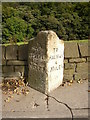
Milestone, Rochdale Road, Sowerby
This is one of the best of the milestones on this road, which escaped replacement by the county council in the late 19C. A mile back towards Halifax an unfortunate milestone is buried up to its neck in tarmac, the level of the road and footway having been raised.
Image: © Humphrey Bolton
Taken: 20 Sep 2007
0.07 miles