IMAGES TAKEN NEAR TO
Norland Road, SOWERBY BRIDGE, HX6 3DF
Introduction
This page details the photographs taken nearby to Norland Road, HX6 3DF by members of the Geograph project.
The Geograph project started in 2005 with the aim of publishing, organising and preserving representative images for every square kilometre of Great Britain, Ireland and the Isle of Man.

There are currently over 7.5m images from over14,400 individuals and you can help contribute to the project by visiting https://www.geograph.org.uk
Image Map
Images are licensed for reuse under creativecommons.org/licenses/by-sa/2.0
Notes
- Clicking on the map will re-center to the selected point.
- The higher the marker number, the further away the image location is from the centre of the postcode.
Image Listing (394 Images Found)
Images are licensed for reuse under creativecommons.org/licenses/by-sa/2.0
Image
Details
Distance
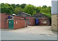
1
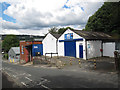
JMS Motorcycles, Norland Road, Sowerby Bridge
Closed as it was a Sunday.
Image: © Stephen Craven
Taken: 6 Jul 2014
0.01 miles
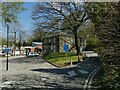
2
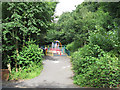
Playground off Norland Road
An almost secret garden.
Image: © Stephen Craven
Taken: 6 Jul 2015
0.03 miles
3
Hope Street with Allan Terrace to the left
Image: © Alexander P Kapp
Taken: 8 Apr 2010
0.03 miles
4
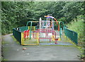
Playground off Norland Road, Sowerby Bridge
Image: © Humphrey Bolton
Taken: 23 Aug 2015
0.03 miles
5
Industrial buildings, Victoria Street
Image: © Humphrey Bolton
Taken: 27 May 2013
0.04 miles
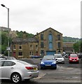
6
Allan House Health Centre, Sowerby Bridge
An NHS health centre near the railway station. The older building was originally Allen House, later Allan House (I don't know why the spelling changed) and was the home of John Radcliffe, mill owner. In 1922, the grounds were opened as Allan Park - there is still a bowling green behind the house - and later, the house was used as offices by the local council.
Image: © Stephen Craven
Taken: 24 Apr 2021
0.04 miles
9
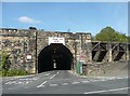
Tunnel under the railway, Sowerby Bridge
Captioned 'tunnel' on the large-scale OS map, but it is actually two bridges on different axes joined together. The carriageway under the furthest bridge is single-track, priority is not given to traffic in either direction, and there is a sharp turn at the far end!
Image: © Humphrey Bolton
Taken: 10 Sep 2009
0.05 miles
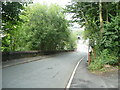
10
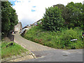
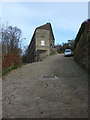
Hope Street, Sowerby Bridge,
The short street rises steeply from Boggart Lane.
Image: © Stephen Craven
Taken: 6 Jul 2015
0.05 miles