IMAGES TAKEN NEAR TO
River Walk, SOWERBY BRIDGE, HX6 3BR
Introduction
This page details the photographs taken nearby to River Walk, HX6 3BR by members of the Geograph project.
The Geograph project started in 2005 with the aim of publishing, organising and preserving representative images for every square kilometre of Great Britain, Ireland and the Isle of Man.

There are currently over 7.5m images from over14,400 individuals and you can help contribute to the project by visiting https://www.geograph.org.uk
Image Map
Images are licensed for reuse under creativecommons.org/licenses/by-sa/2.0
Notes
- Clicking on the map will re-center to the selected point.
- The higher the marker number, the further away the image location is from the centre of the postcode.
Image Listing (351 Images Found)
Images are licensed for reuse under creativecommons.org/licenses/by-sa/2.0
Image
Details
Distance
1
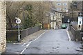
Scar Head Road crosses Stirk Bridge
Scar Head Road was a pack-horse route between Sowerby bridge and Norland in the 17th century. The Stirk Bridge Inn is visible in the background.
Image: © Richard Kay
Taken: 2 Dec 2009
0.01 miles
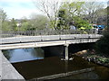
3
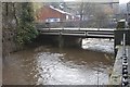
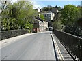
Stirk Bridge, River Ryburn
A cast iron bridge, built in 1859 to replace an older stone arch, see : http://www.calderdale.gov.uk/wtw/search/controlservlet?PageId=Detail&DocId=101843 . The bridge is currently restricted to vehicles with a maximum weight of 3 tonnes.
Image: © Richard Kay
Taken: 2 Dec 2009
0.01 miles
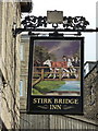
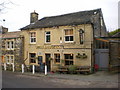
6
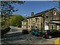
The former Stirk Bridge Inn
Still a going concern in 2009 Image but now closed.
Image: © Stephen Craven
Taken: 24 Apr 2021
0.02 miles
8
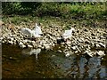
White geese on the Ryburn at Sowerby Bridge
I think these are geese rather than swans but I stand to be corrected.
Image: © Stephen Craven
Taken: 24 Apr 2021
0.02 miles
10
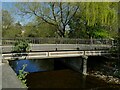
Stirk Bridge over the River Ryburn
The English Heritage listing (grade II, entry 1134551) only describes it as a "mid-late 19th century" iron bridge, but a little online research finds that it was built c.1859 to replace the 17th century stone packhorse bridge on the road to Norland.
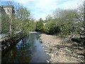
The bridge is seen here in low-flow conditions after a month of dry weather. It looks lovely now on a sunny day, but it would have been a different matter when it was just downstream of a dyeworks.
Image: © Stephen Craven
Taken: 24 Apr 2021
0.02 miles