IMAGES TAKEN NEAR TO
Fern Bank, SOWERBY BRIDGE, HX6 3BG
Introduction
This page details the photographs taken nearby to Fern Bank, HX6 3BG by members of the Geograph project.
The Geograph project started in 2005 with the aim of publishing, organising and preserving representative images for every square kilometre of Great Britain, Ireland and the Isle of Man.

There are currently over 7.5m images from over14,400 individuals and you can help contribute to the project by visiting https://www.geograph.org.uk
Image Map
Images are licensed for reuse under creativecommons.org/licenses/by-sa/2.0
Notes
- Clicking on the map will re-center to the selected point.
- The higher the marker number, the further away the image location is from the centre of the postcode.
Image Listing (262 Images Found)
Images are licensed for reuse under creativecommons.org/licenses/by-sa/2.0
Image
Details
Distance
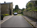
4
Former school, Quarry Hill, Sowerby Bridge
Image: © Humphrey Bolton
Taken: 9 Mar 2012
0.02 miles
5
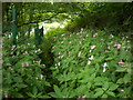
Syke Lane
Its slowly being over taken with Himalayan balsam (Impatiens glandulifera)
Image: © Alexander P Kapp
Taken: 5 Aug 2009
0.03 miles
6
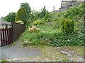
Syke Lane
The lane is wider further down; here it has been encroached upon. It is an unadopted street and Sowerby Bridge FP 160.
Image: © Humphrey Bolton
Taken: 27 May 2013
0.03 miles
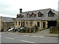
8
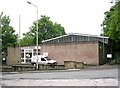
Telephone Exchange - Sowerby New Road
Image: © Betty Longbottom
Taken: 30 May 2008
0.04 miles