IMAGES TAKEN NEAR TO
Sowerby Street, SOWERBY BRIDGE, HX6 3AT
Introduction
This page details the photographs taken nearby to Sowerby Street, HX6 3AT by members of the Geograph project.
The Geograph project started in 2005 with the aim of publishing, organising and preserving representative images for every square kilometre of Great Britain, Ireland and the Isle of Man.

There are currently over 7.5m images from over14,400 individuals and you can help contribute to the project by visiting https://www.geograph.org.uk
Image Map
Images are licensed for reuse under creativecommons.org/licenses/by-sa/2.0
Notes
- Clicking on the map will re-center to the selected point.
- The higher the marker number, the further away the image location is from the centre of the postcode.
Image Listing (338 Images Found)
Images are licensed for reuse under creativecommons.org/licenses/by-sa/2.0
Image
Details
Distance
1
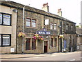
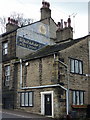
Royal Oak, Sowerby Street
The hanging sign is of the Top o' t Street now whether that was the previous I know not what. The etched name on the windows is Royal Oak
Image: © Alexander P Kapp
Taken: 5 Aug 2009
0.01 miles
3
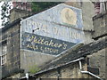
'Ghost sign' on the Royal Oak, Sowerby Street, Sowerby Bridge
There is an older 'RO' to the left of the cock. "Whitakers “Cock o' the North” Brewery Halifax. Whitaker's brewery was founded in 1848 and took its name from Richard Whitaker." (from www.yorkshirenostalgia.co.uk/general-items/.../brewing-in-yorkshire/ )
Image: © Humphrey Bolton
Taken: 20 Jul 2015
0.02 miles
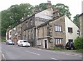
4
No52 Sowerby Street, Sowerby Bridge
Image: © Alexander P Kapp
Taken: 7 Apr 2010
0.02 miles
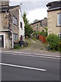
5
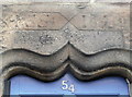
Inscribed lintel above doorway to a 17C house
The house is next to the Royal Oak. It is listed, Grade II and details can be seen here: http://list.historicengland.org.uk/resultsingle.aspx?uid=1185692&searchtype=mapsearch . The details state that the date is 1672, but it looks like 1679 to me.
Image: © Humphrey Bolton
Taken: 27 Jul 2015
0.02 miles
6
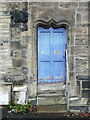
Doorway of 17C house, Sowerby Street, Sowerby Bridge
This house is next to the Royal Oak, and is listed, Grade II - see http://list.historicengland.org.uk/resultsingle.aspx?uid=1185692&searchtype=mapsearch . The front of the house has been altered, and the label stop to the left of the lintel is no longer connected to a drip course. However the door surround is in excellent condition. See Image] for a close view of the inscription on the lintel. The listing details include the following note: "This was the last meeting place of the Quaker Community in Sowerby Bridge (Sowerby Civic Society, Sowerby Bridge Trail, p 7)."
Image: © Humphrey Bolton
Taken: 27 Jul 2015
0.02 miles
7
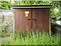
Electricity Substation No 905 - Sowerby Street
Image: © Betty Longbottom
Taken: 8 Jun 2015
0.02 miles
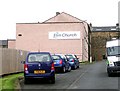
8
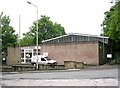
Telephone Exchange - Sowerby New Road
Image: © Betty Longbottom
Taken: 30 May 2008
0.03 miles