IMAGES TAKEN NEAR TO
SOWERBY BRIDGE, HX6 3AD
Introduction
This page details the photographs taken nearby to HX6 3AD by members of the Geograph project.
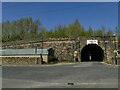
The Geograph project started in 2005 with the aim of publishing, organising and preserving representative images for every square kilometre of Great Britain, Ireland and the Isle of Man.

There are currently over 7.5m images from over14,400 individuals and you can help contribute to the project by visiting https://www.geograph.org.uk
Image Map
Images are licensed for reuse under creativecommons.org/licenses/by-sa/2.0
Notes
- Clicking on the map will re-center to the selected point.
- The higher the marker number, the further away the image location is from the centre of the postcode.
Image Listing (445 Images Found)
Images are licensed for reuse under creativecommons.org/licenses/by-sa/2.0
Image
Details
Distance
1
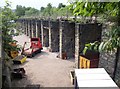
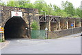
Coal drops, Station Road, Sowerby Bridge
Here coal was tipped out of railway wagons into carts, later lorries, below. There are other examples in Halifax and Fartown, Huddersfield.
Image: © Humphrey Bolton
Taken: 2 Jul 2006
0.01 miles
2
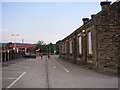
Sowerby Bridge Station
The station was originally to the west of the river bridge, but was moved here when the branch line to Ripponden and Rishworth was opened in 1886. This was intended to be a new main line over to Lancashire, but was not completed and the branch line was uneconomic due to competition by trams and was closed to passenger traffic in the 1930s. Meanwhile a large station had been built, now mostly demolished to make way for a modern factory. However part of the 19C building still exists on the right, and the modern station with canopies over the platforms is on the left.
Image: © Humphrey Bolton
Taken: 2 Jul 2006
0.01 miles
3
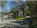
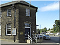
Allan House Health Centre, Sowerby Bridge
An NHS health centre near the railway station. The older building was originally Allen House, later Allan House (I don't know why the spelling changed) and was the home of John Radcliffe, mill owner. In 1922, the grounds were opened as Allan Park - there is still a bowling green behind the house - and later, the house was used as offices by the local council.
Image: © Stephen Craven
Taken: 24 Apr 2021
0.02 miles
4
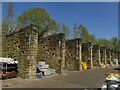
Sowerby Bridge coal drops
This facility for discharging the contents of coal hopper wagons onto road lorries beneath the viaduct has long been disused, and the track above this section has been removed since 2006, see Image The site is now used by a builder's merchant. There are however videos available online of it still being used in the 1970s. Along with the adjacent bridge they are listed grade II (List entry 1134480).
Image: © Stephen Craven
Taken: 24 Apr 2021
0.04 miles
5
Holmes Road
As it emerges from under the Burnley to Leeds railway
Image: © Alexander P Kapp
Taken: 17 Feb 2009
0.04 miles
6
Police Station, Sowerby Bridge
On the corner of Station Road and Norland Road to the south of the town.
Image: © michael ely
Taken: 28 Sep 2008
0.04 miles
7
Railway Bridge MVN2/153 at Station Road / Holmes Road junction
The 1964 Map shows a small building at the wall corner
Image: © Roger Templeman
Taken: 29 May 2018
0.04 miles
8
Bridge MVN2/153 - Holmes Lane, Station Road
Image: © Betty Longbottom
Taken: 30 May 2008
0.05 miles
9
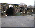
Sowerby Bridge railway bridge over Holmes Road
The bridge is deceptive: as well as being low (indicated maximum height 11ft 3in) it gets narrower in the middle Image This side, at least, dates from 1875; the narrower section supporting the through lines Image may be original to the opening of the line in 1840. Along with the adjacent coal drops it is listed grade II (List entry 1134480).
Image: © Stephen Craven
Taken: 24 Apr 2021
0.06 miles
10
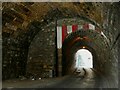
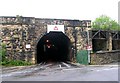
Inside Holmes Road railway bridge, Sowerby Bridge
I took the risk of walking through this bridge, with its narrow carriageway, no pavements and blind bend, to get this view showing how the northern part supporting the original Manchester and Leeds Railway lines of c.1840, is narrower than the later southern part supporting sidings and coal drops. See Image] for context.
Image: © Stephen Craven
Taken: 24 Apr 2021
0.06 miles