IMAGES TAKEN NEAR TO
Daisy Mount, SOWERBY BRIDGE, HX6 2TR
Introduction
This page details the photographs taken nearby to Daisy Mount, HX6 2TR by members of the Geograph project.
The Geograph project started in 2005 with the aim of publishing, organising and preserving representative images for every square kilometre of Great Britain, Ireland and the Isle of Man.

There are currently over 7.5m images from over14,400 individuals and you can help contribute to the project by visiting https://www.geograph.org.uk
Image Map
Images are licensed for reuse under creativecommons.org/licenses/by-sa/2.0
Notes
- Clicking on the map will re-center to the selected point.
- The higher the marker number, the further away the image location is from the centre of the postcode.
Image Listing (115 Images Found)
Images are licensed for reuse under creativecommons.org/licenses/by-sa/2.0
Image
Details
Distance
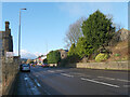
3
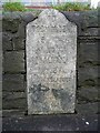
Milestone, Burnley Road, Luddendenfoot
One of a nearly complete set between Halifax and Todmorden. The two that I think are missing are the first one out of Halifax (on King Cross Road) and the one in Hebden Bridge (west of the Heptonstall Road junction). These may never have existed as they are not shown on any of the OS six-inch maps.
Image: © Humphrey Bolton
Taken: 12 Feb 2013
0.03 miles
4
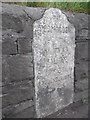
Old Milestone by the A646, Burnley Road, Friendly, Halifax Parish
Carved stone post by the A646, in parish of HALIFAX (CALDERDALE District), Friendly, Burnley Road, opposite No.33, in wall at ground level, on North side of road. Todmorden rolltop, erected by the Todmorden turnpike trust in the 18th/19th century.
Inscription reads:-
TO
TODMORDEN
9 {pointing hand}
TO
HALIFAX
{pointing hand} 2¾
{fancy line}
LUDDENDENFOOT
{fancy line}
Grade II listed
List Entry Number: 1183594 https://historicengland.org.uk/listing/the-list/list-entry/1183594
Milestone Society National ID: YW_TOHA09.
Image: © C Minto
Taken: 1 Dec 2002
0.03 miles
7
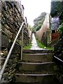
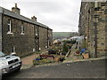
Footpath - Hollins Lane, Sowerby Bridge
Image: © Betty Longbottom
Taken: 1 Oct 2008
0.05 miles

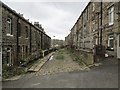
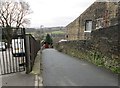
10
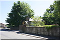
Hollins Lane
There is an OS benchmark Image on the far gatepost of the arch gateway
Image: © Roger Templeman
Taken: 29 Jun 2018
0.08 miles