IMAGES TAKEN NEAR TO
Burnley Road, SOWERBY BRIDGE, HX6 2TF
Introduction
This page details the photographs taken nearby to Burnley Road, HX6 2TF by members of the Geograph project.
The Geograph project started in 2005 with the aim of publishing, organising and preserving representative images for every square kilometre of Great Britain, Ireland and the Isle of Man.

There are currently over 7.5m images from over14,400 individuals and you can help contribute to the project by visiting https://www.geograph.org.uk
Image Map
Images are licensed for reuse under creativecommons.org/licenses/by-sa/2.0
Notes
- Clicking on the map will re-center to the selected point.
- The higher the marker number, the further away the image location is from the centre of the postcode.
Image Listing (67 Images Found)
Images are licensed for reuse under creativecommons.org/licenses/by-sa/2.0
Image
Details
Distance
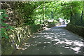
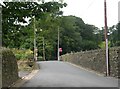
1
Burnley Road - viewed from near Steps Lane
Image: © Betty Longbottom
Taken: 31 May 2014
0.05 miles
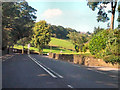
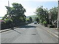
5
Whitty Lane at its junction with Burnley Road
There is an OS benchmark Image on a square stone in the wall half way between the left hand edge of the image and the BT pole
Image: © Roger Templeman
Taken: 23 May 2018
0.08 miles
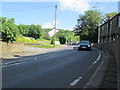
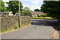
7
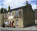
The Bay Horse - Burnley Road, Causeway Head
Image: © Betty Longbottom
Taken: 4 Aug 2008
0.08 miles
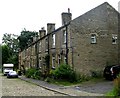
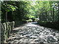
8
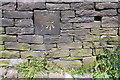
Benchmark on wall of Whitty Lane
Ordnance Survey cut mark benchmark levelled at 176.613m above Newlyn Datum
Image: © Roger Templeman
Taken: 23 May 2018
0.09 miles