IMAGES TAKEN NEAR TO
Ediths View, SOWERBY BRIDGE, HX6 2QL
Introduction
This page details the photographs taken nearby to Ediths View, HX6 2QL by members of the Geograph project.
The Geograph project started in 2005 with the aim of publishing, organising and preserving representative images for every square kilometre of Great Britain, Ireland and the Isle of Man.

There are currently over 7.5m images from over14,400 individuals and you can help contribute to the project by visiting https://www.geograph.org.uk
Image Map
Images are licensed for reuse under creativecommons.org/licenses/by-sa/2.0
Notes
- Clicking on the map will re-center to the selected point.
- The higher the marker number, the further away the image location is from the centre of the postcode.
Image Listing (430 Images Found)
Images are licensed for reuse under creativecommons.org/licenses/by-sa/2.0
Image
Details
Distance
1
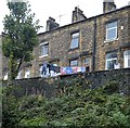
Washing's out!
Hung out to dry in the front gardens of Ediths View on the north bank of the Rochdale Canal in Sowerby Bridge.
Viewed from the Corporation Mill side of the canal.
Image: © Bobby Clegg
Taken: 4 Sep 2015
0.01 miles
2
Canalside garden, Sowerby Bridge
The houses are in Greenups Terrace, the flats in Lodstone Towers. The blue flag is the Yorkshire flag.
Image: © Christine Johnstone
Taken: 8 Dec 2020
0.02 miles
3
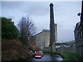
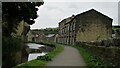
The Rochdale Canal near Corporation Mill #2
The five storey mill was built in 1875 by William Morris & Sons Ltd. of Halifax.
Only the stump of the octagonal sandstone chimney now remains but it would have been a quite a local landmark when it was at its full height.
Image: © Bobby Clegg
Taken: 4 Sep 2015
0.02 miles
5
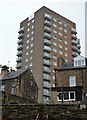
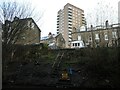
Tower block and terraces in Sowerby Bridge
Ladstone Towers looks as though it was probably built in the 1960s, although I'm not sure what year. In this view, against a rather overcast sky, the tower block looms above the Victorian terraces of Dale Terrace and Orion Place below.
Viewed from the Rochdale Canal next to Corporation Mill.
Image: © Bobby Clegg
Taken: 4 Sep 2015
0.02 miles
6

Little England, Sowerby Bridge
One of the householders on Greenup Terrace has claimed a bit of the steep canal bank at the bottom of their garden and flying the flag proudly for England.
Image: © Stephen Craven
Taken: 16 Feb 2019
0.02 miles
7
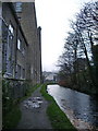
Canalside Buildings
Besides the Rochdale Canal are Hollins Mill and The Works. Just under the tree is the truncated Corporation Mill Chimney which is listed but demolished when deemed unsafe
Image: © Kevin Waterhouse
Taken: 10 Sep 2020
0.02 miles
8
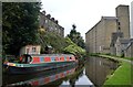
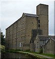
The Rochdale Canal near Corporation Mill
The canal passes between Edith's Terrace to the left and Corporation Mill to the right of the image. The moored narrowboat on the north bank is named Zusammen.
Comparing this to a photo taken from more or less the same spot by Dr. Neil Clifton in May 1990, the canal has been very well rstored and is in full water these days. The five storey mill still looks much as it did, but the octagonal stone chimney has been truncated almost down to the level of its plinth.
Image: © Bobby Clegg
Taken: 4 Sep 2015
0.03 miles
9
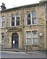
Old Sowerby Bridge Council Offices - Hollins Mill Lane
Image: © Betty Longbottom
Taken: 30 May 2008
0.03 miles