IMAGES TAKEN NEAR TO
Albert Road, SOWERBY BRIDGE, HX6 2PA
Introduction
This page details the photographs taken nearby to Albert Road, HX6 2PA by members of the Geograph project.
The Geograph project started in 2005 with the aim of publishing, organising and preserving representative images for every square kilometre of Great Britain, Ireland and the Isle of Man.

There are currently over 7.5m images from over14,400 individuals and you can help contribute to the project by visiting https://www.geograph.org.uk
Image Map
Images are licensed for reuse under creativecommons.org/licenses/by-sa/2.0
Notes
- Clicking on the map will re-center to the selected point.
- The higher the marker number, the further away the image location is from the centre of the postcode.
Image Listing (285 Images Found)
Images are licensed for reuse under creativecommons.org/licenses/by-sa/2.0
Image
Details
Distance
1
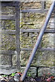
Benchmark on #14 Albert Road
Ordnance Survey cut mark benchmark levelled at 122.268m above Newlyn Datum
Image: © Roger Templeman
Taken: 23 May 2018
0.03 miles
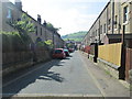
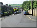
2
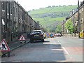
Albert Road - viewed from Clay Street
Image: © Betty Longbottom
Taken: 31 May 2014
0.03 miles
4
#1 Princess Street at Clay Street / Albert Road junction
Image: © Roger Templeman
Taken: 23 May 2018
0.04 miles
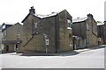
6
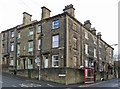
Sowerby Bridge - houses at Beech Road / Albert Road junction
Image: © Dave Bevis
Taken: 19 Feb 2014
0.05 miles
8
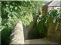
The top of Sugden Bank at Beech Road, Sowerby Bridge
Sugden Bank is Sowerby Bridge FP44.
Image: © Humphrey Bolton
Taken: 2 Aug 2018
0.06 miles
9
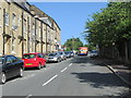
Victoria Avenue - viewed from Clay Street
Image: © Betty Longbottom
Taken: 31 May 2014
0.06 miles
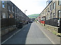
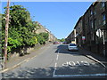
10
Albert Road - viewed from Clay Street
Image: © Betty Longbottom
Taken: 31 May 2014
0.06 miles