IMAGES TAKEN NEAR TO
Church View, SOWERBY BRIDGE, HX6 2LW
Introduction
This page details the photographs taken nearby to Church View, HX6 2LW by members of the Geograph project.
The Geograph project started in 2005 with the aim of publishing, organising and preserving representative images for every square kilometre of Great Britain, Ireland and the Isle of Man.

There are currently over 7.5m images from over14,400 individuals and you can help contribute to the project by visiting https://www.geograph.org.uk
Image Map
Images are licensed for reuse under creativecommons.org/licenses/by-sa/2.0
Notes
- Clicking on the map will re-center to the selected point.
- The higher the marker number, the further away the image location is from the centre of the postcode.
Image Listing (401 Images Found)
Images are licensed for reuse under creativecommons.org/licenses/by-sa/2.0
Image
Details
Distance
1
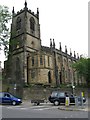
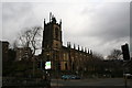
Christ Church
Originally dated 1819, the chancel was re-built 1873-79.
Image: © Alan Longbottom
Taken: 30 May 2008
0.01 miles
3
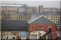
Sowerby Bridge
From the station platform, Sowerby Bridge has a distinctly workaday appearance, relieved only by the parish church, and not helped here by the rainy weather conditions. Nevertheless, the town seems to be arranged in layers up the side of the valley.
Image: © Stephen McKay
Taken: 6 Dec 2007
0.01 miles
4
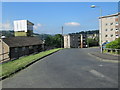
Church View - viewed from Sunnybank Street
Image: © Betty Longbottom
Taken: 31 May 2014
0.01 miles
5
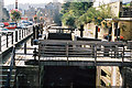
Tuel Lane Deep Lock No. 3/4, Rochdale Canal, Sowerby Bridge
Seen soon after the canal was re-opened throughout. The assistance of the lock keeper is obligatory for boaters wishing to use this lock.
Image: © Dr Neil Clifton
Taken: 29 Sep 2002
0.02 miles
6
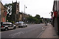
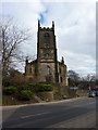
Christ Church, Sowerby Bridge
Looking along the A58 with Tuel Lane heading left from the junction.
Image: © Mark Anderson
Taken: 6 Aug 2005
0.02 miles
7
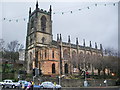
Christ Church, Sowerby Bridge
The road coming down the hill from the left is the bottom part of Tuel Lane, but until the 1950s there was no road here, just the canal. The road across the front of the picture is Wharf Street, part of the A58.
Image: © Dr Neil Clifton
Taken: 23 Feb 2008
0.02 miles
9
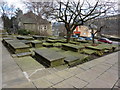
Christ Church, Sowerby Bridge, Graveyard
Image: © Alexander P Kapp
Taken: 11 Mar 2010
0.02 miles
10
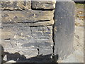
Cut Mark Orrel House Church Bank Sowerby Bridge
Image: © Monica Stagg
Taken: 9 Aug 2015
0.02 miles