IMAGES TAKEN NEAR TO
Barge Avenue, SOWERBY BRIDGE, HX6 2FL
Introduction
This page details the photographs taken nearby to Barge Avenue, HX6 2FL by members of the Geograph project.
The Geograph project started in 2005 with the aim of publishing, organising and preserving representative images for every square kilometre of Great Britain, Ireland and the Isle of Man.

There are currently over 7.5m images from over14,400 individuals and you can help contribute to the project by visiting https://www.geograph.org.uk
Image Map
Images are licensed for reuse under creativecommons.org/licenses/by-sa/2.0
Notes
- Clicking on the map will re-center to the selected point.
- The higher the marker number, the further away the image location is from the centre of the postcode.
Image Listing (72 Images Found)
Images are licensed for reuse under creativecommons.org/licenses/by-sa/2.0
Image
Details
Distance
1
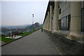
Copley Data Centre
Close by the Copley Data Centre, looking westwards towards Sowerby Bridge.
Image: © Peter Crump
Taken: 31 Jan 2006
0.02 miles
2
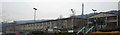
Copley Data Centre
This is the HBOS (Halifax Bank of Scotland) Data Centre at Copley, with the Wainhouse Tower beyond. On the OS map, this is the large, long building between Delph Hill and the Wakefield Road (A6026).
Image: © Peter Crump
Taken: 31 Jan 2006
0.02 miles
3
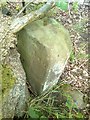
Old milemarker east of Sowerby Bridge, Halifax
Milemarker by the Calder & Hebble Navigation, in parish of Halifax (Calderdale District), East of Sowerby Bridge, near Wakefield Road.
Surveyed
Milestone Society National ID: CHN-21
Image: © Milestone Society
Taken: Unknown
0.02 miles
4
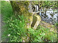
Forgotten milestone on the Calder and Hebble Navigation
I thought that this would be shown on old 1:2500 maps, but they do not seem to show canal milestones. I will see if I can read the inscription next time I pass it.
Image: © Humphrey Bolton
Taken: 19 May 2014
0.03 miles
5
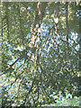
Reflected tree
Yes, the photo is this way up! A tree reflected in the still waters of the Calder & Hebble Canal (the bit of ground in the bottom corner confirms it).
Image: © Stephen Craven
Taken: 29 Aug 2010
0.06 miles
6
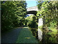
Copley Viaduct spans the Calder and Hebble Navigation
Image: © Raymond Knapman
Taken: 6 Oct 2021
0.06 miles
7
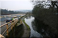
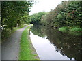
Calder & Hebble Navigation
Looking westwards along the Calder & Hebble Navigation from the bridge at SE078232.
Image: © Peter Crump
Taken: 31 Jan 2006
0.11 miles
8
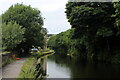
Calder and Hebble Navigation next to Hollas Road
The canal is squeezed between the A6026 Wakefield Road and the River Calder
Image: © Chris Heaton
Taken: 15 Aug 2021
0.11 miles
10
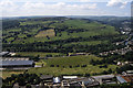
Calder Valley with Norland Moor beyond from Wainhouse Tower
Image: © Colin Park
Taken: 21 Jun 1998
0.12 miles