IMAGES TAKEN NEAR TO
St. Anns Square, SOWERBY BRIDGE, HX6 2FA
Introduction
This page details the photographs taken nearby to St. Anns Square, HX6 2FA by members of the Geograph project.
The Geograph project started in 2005 with the aim of publishing, organising and preserving representative images for every square kilometre of Great Britain, Ireland and the Isle of Man.

There are currently over 7.5m images from over14,400 individuals and you can help contribute to the project by visiting https://www.geograph.org.uk
Image Map
Images are licensed for reuse under creativecommons.org/licenses/by-sa/2.0
Notes
- Clicking on the map will re-center to the selected point.
- The higher the marker number, the further away the image location is from the centre of the postcode.
Image Listing (424 Images Found)
Images are licensed for reuse under creativecommons.org/licenses/by-sa/2.0
Image
Details
Distance
1
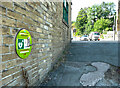
Defibrillator opposite Tuel Lane, Sowerby Bridge
This one is unusual in being built into the wall of a building.
Image: © Humphrey Bolton
Taken: 2 Sep 2021
0.00 miles
2
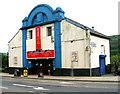
The Roxy Bingo Hall - Wharf Street
Formerly a cinema.
Image: © Betty Longbottom
Taken: 30 May 2008
0.01 miles
3
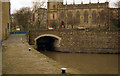
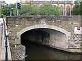
Tuel Lane Tunnel in Sowerby Bridge
Bridge No.1 on the Rochdale Canal, this short tunnel takes the canal under the A58 Wharf Street and the A6139 Tuel Lane emerging to the north of the Commercial Inn.
Viewed from the pound above Lock No.1.
Image: © Bobby Clegg
Taken: 4 Sep 2015
0.01 miles
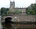
4
Tuel Lane canal tunnel and the parish church, Sowerby Bridge
This is a revisit to the first geograph for the square: Image], taken in May 1996. The church is Christ Church, built in 1819 and rebuilt in 1874.
Image: © Humphrey Bolton
Taken: 2 Sep 2021
0.01 miles
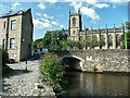
5
Above Lock No 2, Rochdale Canal
Area tidied up as the new lock and tunnel were under construction. The tunnel will emerge under this bridge.
Image: © Dr Neil Clifton
Taken: Unknown
0.01 miles
6
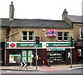
Sowerby Bridge Post Office - Wharf Street
Image: © Betty Longbottom
Taken: 30 May 2008
0.01 miles
7

'The Wharf' public house, Sowerby Bridge
This is the premises of the former 'Commercial Inn', after being subjected to a process of extension and trendification, presumably in an attempt to attract the younger generation of drinkers in Sowerby Bridge.
Image: © Dr Neil Clifton
Taken: 23 Feb 2008
0.01 miles
8
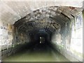
Tuel Lane Tunnel, the Rochdale Canal
When the canal was restored, this 114 yard tunnel was created under Tuel Lane.
Image: © Christine Johnstone
Taken: 22 May 2010
0.02 miles
9
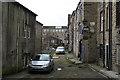
St. Ann's Square, Sowerby Bridge
See also Image I had expected these buildings would have disappeared since I was here previously, but incredibly there is still human habitation - and not by poor people either - '54' reg. Volvo V70s do not come cheap. In the background the Turk's Head can be seen and behind that, the Carlton Mill.
Image: © Dr Neil Clifton
Taken: 23 Feb 2008
0.02 miles
10
Tuel Lane Tunnel (Bridge 1)
Rochdale Canal - carries A6139 over canal, just below Tuel Lane Lock 3/4
Image: © Mike Todd
Taken: 17 Jun 2011
0.02 miles