IMAGES TAKEN NEAR TO
Orchard Rise, SOWERBY BRIDGE, HX6 1EJ
Introduction
This page details the photographs taken nearby to Orchard Rise, HX6 1EJ by members of the Geograph project.
The Geograph project started in 2005 with the aim of publishing, organising and preserving representative images for every square kilometre of Great Britain, Ireland and the Isle of Man.

There are currently over 7.5m images from over14,400 individuals and you can help contribute to the project by visiting https://www.geograph.org.uk
Image Map
Images are licensed for reuse under creativecommons.org/licenses/by-sa/2.0
Notes
- Clicking on the map will re-center to the selected point.
- The higher the marker number, the further away the image location is from the centre of the postcode.
Image Listing (113 Images Found)
Images are licensed for reuse under creativecommons.org/licenses/by-sa/2.0
Image
Details
Distance
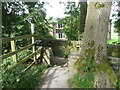
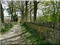
1
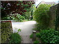
Sowerby bridge FP97 crossing Orchard Rise
Presumably the bollards are to deter fly-tipping on the wide path, which is part of Brockwell Lane.
Image: © Humphrey Bolton
Taken: 29 Aug 2015
0.02 miles
2
Sowerby Bridge FP97 on Brockwell Lane
Image: © Humphrey Bolton
Taken: 29 Aug 2015
0.02 miles
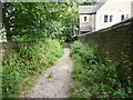
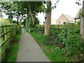
3
Footpath behind Ryburn Valley High School
The path connects Brock Well Lane with Dean Lane.
Image: © Stephen Craven
Taken: 24 Apr 2021
0.03 miles
5
Junction of Sowerby bridge FP98 with Brock Well Lane
Image: © Humphrey Bolton
Taken: 29 Aug 2015
0.03 miles
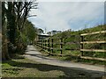
6
Sowerby Bridge FP99 passing Orchard Rise
There is a staggered barrier here as the path approaches Brock Well Lane.
Image: © Humphrey Bolton
Taken: 29 Aug 2015
0.03 miles
7
Brockwell Lane, Sowerby Bridge FP97
This is looking up from the junction with FP98 at the entrance to Brock Well Mill.
Image: © Humphrey Bolton
Taken: 29 Aug 2015
0.06 miles
8
Sowerby bridge FP98 at Brock Well Mill
The path goes between one of the mill buildings, now converted to a house, on the left and a house attached to Brock Well House on the right.
Image: © Humphrey Bolton
Taken: 29 Aug 2015
0.06 miles
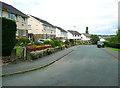
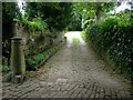
9
The top of Brock Well Lane
This top section of the lane is only a public footpath. See also Image
Image: © Stephen Craven
Taken: 24 Apr 2021
0.06 miles
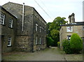
10
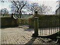
Entrance to Brock Well House
For the house itself, see Image
Image: © Stephen Craven
Taken: 24 Apr 2021
0.07 miles