IMAGES TAKEN NEAR TO
Whiteley Avenue, SOWERBY BRIDGE, HX6 1DL
Introduction
This page details the photographs taken nearby to Whiteley Avenue, HX6 1DL by members of the Geograph project.
The Geograph project started in 2005 with the aim of publishing, organising and preserving representative images for every square kilometre of Great Britain, Ireland and the Isle of Man.

There are currently over 7.5m images from over14,400 individuals and you can help contribute to the project by visiting https://www.geograph.org.uk
Image Map
Images are licensed for reuse under creativecommons.org/licenses/by-sa/2.0
Notes
- Clicking on the map will re-center to the selected point.
- The higher the marker number, the further away the image location is from the centre of the postcode.
Image Listing (84 Images Found)
Images are licensed for reuse under creativecommons.org/licenses/by-sa/2.0
Image
Details
Distance
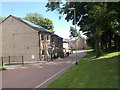
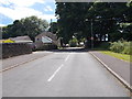
1
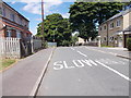
Beechwood Avenue - Whiteley Avenue
Image: © Betty Longbottom
Taken: 30 Jun 2015
0.02 miles
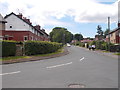
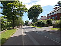
3
Richmond Gardens - Richmond Avenue
Image: © Betty Longbottom
Taken: 30 Jun 2015
0.06 miles
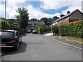
5
Hollybush Close - Beechwood Avenue
Image: © Betty Longbottom
Taken: 30 Jun 2015
0.07 miles
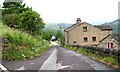
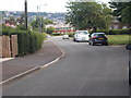
7
Upper Gaukroger, Sowerby New Road, Sowerby
These houses were here before the new road was constructed, and they fronted onto a narrow lane that came from Haugh End lane via Upper and Lower Bentley Royd.
Image: © Humphrey Bolton
Taken: 27 Feb 2009
0.07 miles
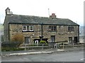
8
Bates Avenue - St Peter's Avenue, Sowerby
Image: © Betty Longbottom
Taken: 1 Oct 2008
0.08 miles
9
Beechwood Avenue - Sowerby New Road
Image: © Betty Longbottom
Taken: 30 Jun 2015
0.08 miles
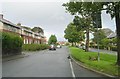
10
Fore Lane Avenue - Sowerby New Road
Image: © Betty Longbottom
Taken: 30 Jun 2015
0.08 miles