IMAGES TAKEN NEAR TO
SOWERBY BRIDGE, HX6 1BE
Introduction
This page details the photographs taken nearby to HX6 1BE by members of the Geograph project.
The Geograph project started in 2005 with the aim of publishing, organising and preserving representative images for every square kilometre of Great Britain, Ireland and the Isle of Man.

There are currently over 7.5m images from over14,400 individuals and you can help contribute to the project by visiting https://www.geograph.org.uk
Image Map
Images are licensed for reuse under creativecommons.org/licenses/by-sa/2.0
Notes
- Clicking on the map will re-center to the selected point.
- The higher the marker number, the further away the image location is from the centre of the postcode.
Image Listing (100 Images Found)
Images are licensed for reuse under creativecommons.org/licenses/by-sa/2.0
Image
Details
Distance
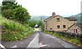
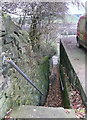
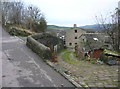
2
Sowerby Bridge FP73 (East) at Fore Lane Avenue
Image: © Humphrey Bolton
Taken: 5 Dec 2017
0.03 miles
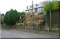
3
Fore Lane Avenue, Sowerby
This is a continuation of Fore Lane, which is further to the east.
Image: © Humphrey Bolton
Taken: 19 Jul 2010
0.03 miles
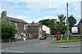
4
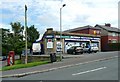
Post Office, Tillotson Avenue, Sowerby
The building is dated 1928 on the corner.
Image: © Humphrey Bolton
Taken: 19 Jul 2010
0.03 miles
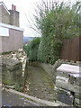
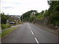
5
Sowerby Bridge FP73 East and West, Sowerby New Road
Strange that there are two paths so close together between Sowerby New Road and Fore Lane Avenue.
Image: © Humphrey Bolton
Taken: 5 Dec 2017
0.04 miles
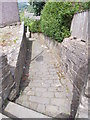
7
Sowerby Bridge FP73 (West) at Fore Lane Avenue, Sowerby
Image: © Humphrey Bolton
Taken: 5 Dec 2017
0.04 miles
9
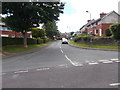
Richmond Avenue - Fore Lane Avenue
Image: © Betty Longbottom
Taken: 30 Jun 2015
0.08 miles