IMAGES TAKEN NEAR TO
Lower Edge Road, ELLAND, HX5 9QD
Introduction
This page details the photographs taken nearby to Lower Edge Road, HX5 9QD by members of the Geograph project.
The Geograph project started in 2005 with the aim of publishing, organising and preserving representative images for every square kilometre of Great Britain, Ireland and the Isle of Man.

There are currently over 7.5m images from over14,400 individuals and you can help contribute to the project by visiting https://www.geograph.org.uk
Image Map
Images are licensed for reuse under creativecommons.org/licenses/by-sa/2.0
Notes
- Clicking on the map will re-center to the selected point.
- The higher the marker number, the further away the image location is from the centre of the postcode.
Image Listing (114 Images Found)
Images are licensed for reuse under creativecommons.org/licenses/by-sa/2.0
Image
Details
Distance
1
Morley Corporation Water Works 15" Main plate
This marks a point where the main leaves the road.
Image: © Humphrey Bolton
Taken: 23 Apr 2013
0.02 miles
2

Houses on Lower Edge Road, Rastrick
No.109 has a nicely carved datestone: No.1 / J Rangley / 1813. The pair of cottages (now one house) beyond look older, having a lower roof and a kneeler at the end of the verge of the gable.
Image: © Humphrey Bolton
Taken: 31 May 2006
0.02 miles
3

Minstead Avenue, Rastrick
A street that didn't get very far, with just one pair of semis.
Image: © Humphrey Bolton
Taken: 31 May 2006
0.02 miles
4

Former Co-op shop and terrace houses, Lower Edge Road, Elland
The building on the corner was a co-op shop, but has been re-fronted and the only clues are the taking-in door on the first floor of the gable-end and the post box built into the wall. The terrace houses have a plaque inscribed 'C. SUGDEN'S TERRACE A.D.1886'.
Image: © Humphrey Bolton
Taken: 8 Jun 2006
0.02 miles
5

The Old Clubhouse, Lower Edge Road, Elland
This was rebuilt in 2004. The clubhouse was possibly for the bowling green that was here in 1908. The post on the left is for the inn-sign for the Royal Oak Inn – however there isn't a sign at present.
Image: © Humphrey Bolton
Taken: 1 Jan 2007
0.02 miles
6
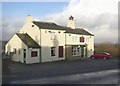
The Royal Oak Inn, Lower Edge Road, Elland
The classic place for an inn, at the top of a steep hill on a medieval main road. It certainly existed in 1850, when it was shown on the 6” OS map. It looks quiet now at 12:13, but later at around 1pm the customers were arriving.
Image: © Humphrey Bolton
Taken: 1 Jan 2007
0.02 miles
7

Datestone for C. Sugden's Terrace, Lower Edge Road, Elland
I rather liked the lettering on this stone.
Image: © Humphrey Bolton
Taken: 17 Jun 2007
0.02 miles
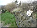
8
Elland FP15 at Lower Edge Road
The house was the Royal Oak Inn.
Image: © Humphrey Bolton
Taken: 6 Sep 2015
0.02 miles

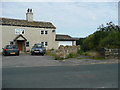
10

The Royal Oak, Lower Edge Road, Elland
Image: © Alexander P Kapp
Taken: 17 Jul 2009
0.03 miles