IMAGES TAKEN NEAR TO
Elland Road, ELLAND, HX5 9JB
Introduction
This page details the photographs taken nearby to Elland Road, HX5 9JB by members of the Geograph project.
The Geograph project started in 2005 with the aim of publishing, organising and preserving representative images for every square kilometre of Great Britain, Ireland and the Isle of Man.

There are currently over 7.5m images from over14,400 individuals and you can help contribute to the project by visiting https://www.geograph.org.uk
Image Map
Images are licensed for reuse under creativecommons.org/licenses/by-sa/2.0
Notes
- Clicking on the map will re-center to the selected point.
- The higher the marker number, the further away the image location is from the centre of the postcode.
Image Listing (73 Images Found)
Images are licensed for reuse under creativecommons.org/licenses/by-sa/2.0
Image
Details
Distance
1

Waterside Lodges, Cromwell Bottom, Southowram
These are holiday lodges. See Image for the lodges under construction.
Image: © Humphrey Bolton
Taken: 2 Mar 2020
0.05 miles

3

Waterside Lodges, The Calder and Hebble Navigation
Image: © habiloid
Taken: 15 Apr 2022
0.08 miles
4
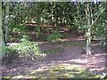
Woodland on former fields, Far Binns, Southowram
This land was one of the fields adjoining Far Binns, shown as a field on the mid-20C 6" map. Sycamores grow quickly, and it does not take long for woodland to form. This is taken from the bridleway.
Image: © Humphrey Bolton
Taken: 23 Sep 2006
0.10 miles
5
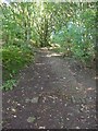
Stone setts on bridleway near site of Far Binns, Southowram
This is approaching the junction with Binns Lane.
Image: © Humphrey Bolton
Taken: 23 Sep 2006
0.10 miles
6
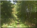
Bridleway from Elland Road to Binns Lane, Southowram
This seems to have been made in the late 19C as an alternative access to Far Binns. It is erroneously marked on the OS Explorer map as a public footpath, but a sign on a gate states that it is a bridleway. The fence on the right protects a naturist caravan park.
Image: © Humphrey Bolton
Taken: 23 Sep 2006
0.10 miles
7
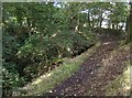
Binns Lane, Southowram
This is the part alongside a clough (small steep-sided valley) not far below the remains of Far Binns. This is now a footpath, although the continuation up to Southowram village via Ashday Hall is a bridleway.
Image: © Humphrey Bolton
Taken: 6 Oct 2006
0.10 miles
10

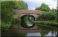
Calder & Hebble Navigation looking West from Crowther's Bridge
Image: © Michael Steele
Taken: 12 Oct 2014
0.11 miles