IMAGES TAKEN NEAR TO
Myrtle Road, ELLAND, HX5 0HU
Introduction
This page details the photographs taken nearby to Myrtle Road, HX5 0HU by members of the Geograph project.
The Geograph project started in 2005 with the aim of publishing, organising and preserving representative images for every square kilometre of Great Britain, Ireland and the Isle of Man.

There are currently over 7.5m images from over14,400 individuals and you can help contribute to the project by visiting https://www.geograph.org.uk
Image Map
Images are licensed for reuse under creativecommons.org/licenses/by-sa/2.0
Notes
- Clicking on the map will re-center to the selected point.
- The higher the marker number, the further away the image location is from the centre of the postcode.
Image Listing (194 Images Found)
Images are licensed for reuse under creativecommons.org/licenses/by-sa/2.0
Image
Details
Distance
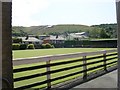
1
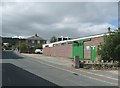
Smith's Filters Ltd., South Lane, Elland
A modern factory on part of the site of Albion Mill.
Image: © Humphrey Bolton
Taken: 30 Aug 2010
0.02 miles
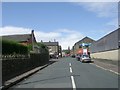
2
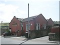
Elland Working Men's Club & Institute - Rosebery Street
Image: © Betty Longbottom
Taken: 21 Aug 2009
0.02 miles
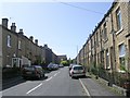
4
Bowling Green - Elland Working Men's Club & Institute - Rosebery Street
Image: © Betty Longbottom
Taken: 21 Aug 2009
0.04 miles
6
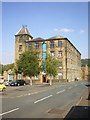
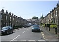
Mill on the corner of Frances and James Street
Image: © Alexander P Kapp
Taken: 2 Jul 2009
0.04 miles
9
Benchmark on a gatepost on Charles Street
Image: © John Slater
Taken: 17 Jun 2012
0.05 miles