IMAGES TAKEN NEAR TO
ELLAND, HX5 0BG
Introduction
This page details the photographs taken nearby to HX5 0BG by members of the Geograph project.
The Geograph project started in 2005 with the aim of publishing, organising and preserving representative images for every square kilometre of Great Britain, Ireland and the Isle of Man.

There are currently over 7.5m images from over14,400 individuals and you can help contribute to the project by visiting https://www.geograph.org.uk
Image Map
Images are licensed for reuse under creativecommons.org/licenses/by-sa/2.0
Notes
- Clicking on the map will re-center to the selected point.
- The higher the marker number, the further away the image location is from the centre of the postcode.
Image Listing (326 Images Found)
Images are licensed for reuse under creativecommons.org/licenses/by-sa/2.0
Image
Details
Distance
1
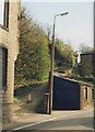
Gog Hill, Elland
A steep cobbled footpath leading from Elland Bridge up to the ancient inn known as the Great House.
Image: © Stephen Craven
Taken: 4 May 1996
0.02 miles

6
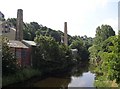
View from Elland Bridge, looking west
On the left the old mills are squeezed in between the steep hillside and the river.
Image: © Humphrey Bolton
Taken: 17 Aug 2005
0.05 miles
7

Datestone on Elland Bridge
This commemorates the widening in 1897.
Image: © Humphrey Bolton
Taken: 23 Sep 2006
0.05 miles
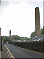
8
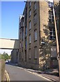
The Exchange Mill warehouse, Saddleworth Road, Elland
This was built of dressed stone, with stone slate roof, in the early to mid-19C. The central bay has loading doors one above the other, the topmost surmounted by a small venetian window now blocked. The side of the building is eight windows wide, built on land quarried out of the hillside. The bridge connects it to what was the Calder Dye Works over the road. On the right is the foot of Gog Hill.
Image: © Humphrey Bolton
Taken: 23 Sep 2006
0.05 miles
9
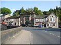
Britannia House, Briggate, Elland
Britannia House is the central building, facing the Elland Bridge. It was built in 1895 for the former Halifax and Huddersfield Union Banking Co. It is in an ornate style with giant columns of Aberdeen granite, the arms of Halifax and Huddersfield, and a seated figure of Britannia in the apex of the pediment. On one side is the Malt Shovel and on the other The Bridge, both 18C inns although the latter looks to have been 'modernised' in the 19C.
Image: © Humphrey Bolton
Taken: 17 May 2010
0.05 miles
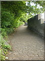
10
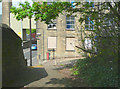
The bottom of Gog Hill
The old name plate is still there below the new one.
Image: © Humphrey Bolton
Taken: 16 May 2013
0.05 miles