IMAGES TAKEN NEAR TO
Broomhill Bottom, HALIFAX, HX4 9LJ
Introduction
This page details the photographs taken nearby to Broomhill Bottom, HX4 9LJ by members of the Geograph project.
The Geograph project started in 2005 with the aim of publishing, organising and preserving representative images for every square kilometre of Great Britain, Ireland and the Isle of Man.

There are currently over 7.5m images from over14,400 individuals and you can help contribute to the project by visiting https://www.geograph.org.uk
Image Map (Loading...)


Getting Data...Please wait
Leaflet Map data © OpenStreetMap
Images are licensed for reuse under creativecommons.org/licenses/by-sa/2.0
Notes
- Clicking on the map will re-center to the selected point.
- The higher the marker number, the further away the image location is from the centre of the postcode.
Image Listing (41 Images Found)
Images are licensed for reuse under creativecommons.org/licenses/by-sa/2.0
Image
Details
Distance
1
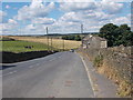
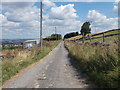
Forest Hill Road - viewed from Moor Hey Lane
Image: © Betty Longbottom
Taken: 7 Aug 2015
0.03 miles
2
Broom Hill Road
This is the start of the bridleway around the west side of Stainland Moor near Sowood Green.
Image: © michael ely
Taken: 21 Sep 2008
0.04 miles
3
Broom Hill Road approaching Forest Hill Road, Stainland
This is Elland Bridleway 73/5. The lane continues on the other side of Forest Hill Road, but is only classed as a footpath.
Image: © Humphrey Bolton
Taken: 22 Apr 2022
0.05 miles
6
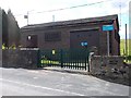
Raw Waste Pumping Station - Forest Hill Road
On the left of the picture is Electricity Substation No 2480.
Image: © Betty Longbottom
Taken: 7 Aug 2015
0.05 miles
7
Forest Hill Road - viewed from Moor Hey Lane
Image: © Betty Longbottom
Taken: 7 Aug 2015
0.06 miles
8
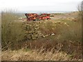
Quarry machinery, Forest Hill Road, Stainland
Like many around here, this quarry is being levelled. The machine might be a stone-crusher for turning all the left-over stone into saleable aggregate.
Image: © Humphrey Bolton
Taken: 7 Feb 2008
0.07 miles
9
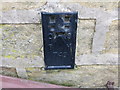
Ordnance Survey Flush Bracket 749
This can be found on the wall of New Bailey Farm (now private dwelling).
For more detail see : http://www.bench-marks.org.uk/log?bm_key=9906
Image: © Peter Wood
Taken: 3 Mar 2013
0.08 miles
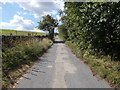
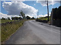
10
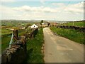
Broom Hill Road towards New Bailey, Stainland
This is Elland Bridleway 73/5.
Image: © Humphrey Bolton
Taken: 22 Apr 2022
0.10 miles