IMAGES TAKEN NEAR TO
Sandbed, HALIFAX, HX4 9JA
Introduction
This page details the photographs taken nearby to Sandbed, HX4 9JA by members of the Geograph project.
The Geograph project started in 2005 with the aim of publishing, organising and preserving representative images for every square kilometre of Great Britain, Ireland and the Isle of Man.

There are currently over 7.5m images from over14,400 individuals and you can help contribute to the project by visiting https://www.geograph.org.uk
Image Map
Images are licensed for reuse under creativecommons.org/licenses/by-sa/2.0
Notes
- Clicking on the map will re-center to the selected point.
- The higher the marker number, the further away the image location is from the centre of the postcode.
Image Listing (66 Images Found)
Images are licensed for reuse under creativecommons.org/licenses/by-sa/2.0
Image
Details
Distance
3
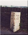
Old Milestone, on the B6112, Stainland Road
Sowood, nr Sowood Community Centre & LP147. Located on the East side of road, in tarmac at edge of road, back to wall. Carved stone post, 19th century. Alternative views see http://www.geograph.org.uk/photo/6740639 & http://www.geograph.org.uk/photo/585490
Inscription reads: HALIFAX / 5 / MILES // HUDDERSFIELD / 4¾ MILES
Milestone Society National ID: YW_HAOU05
Image: © Christine Minto
Taken: 30 Dec 2005
0.03 miles
4

Old milestone
On the B6112, Stainland Road in Sowood. This stone has been painted in recent years and the slim arrows picked out. Well cared for but not 'listed'. On the Salterhebble, Stainland, Sowerby Bridge turnpike of 1824.
Image: © Robert Glover
Taken: 7 Oct 2020
0.03 miles
5
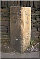
Milestone, Stainland Road, Sowood Green, Stainland
This is on what was the turnpike road from Salterhebble to New Hey Road, Outlane, authorised in 1824. The road is now the B6112.
Image: © Humphrey Bolton
Taken: 15 Oct 2007
0.03 miles
6

Footpath - Moormires Lane - Stainland Road
Image: © Betty Longbottom
Taken: 7 Aug 2015
0.04 miles
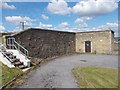
9
Sowood Community Centre, Stainland
This is in a former primary school.
Image: © Humphrey Bolton
Taken: 22 Apr 2022
0.06 miles
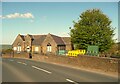
10
Knowl Top, Sowood Green, Stainland
A group of houses in the gap between Stainland village and Sowood Green.
Image: © Humphrey Bolton
Taken: 15 Oct 2007
0.07 miles