IMAGES TAKEN NEAR TO
Knowle Top, HALIFAX, HX4 9HX
Introduction
This page details the photographs taken nearby to Knowle Top, HX4 9HX by members of the Geograph project.
The Geograph project started in 2005 with the aim of publishing, organising and preserving representative images for every square kilometre of Great Britain, Ireland and the Isle of Man.

There are currently over 7.5m images from over14,400 individuals and you can help contribute to the project by visiting https://www.geograph.org.uk
Image Map (Loading...)


Getting Data...Please wait
Leaflet Map data © OpenStreetMap
Images are licensed for reuse under creativecommons.org/licenses/by-sa/2.0
Notes
- Clicking on the map will re-center to the selected point.
- The higher the marker number, the further away the image location is from the centre of the postcode.
Image Listing (45 Images Found)
Images are licensed for reuse under creativecommons.org/licenses/by-sa/2.0
Image
Details
Distance
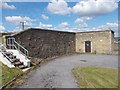
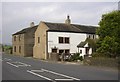
2
New Laith Farm - Knowle Top, Sowood
Image: © Betty Longbottom
Taken: 24 May 2008
0.01 miles
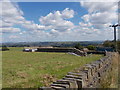
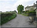
3

Footpath - Moormires Lane - Stainland Road
Image: © Betty Longbottom
Taken: 7 Aug 2015
0.04 miles
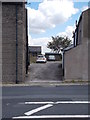
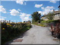
4
Knowl Top, Sowood Green, Stainland
A group of houses in the gap between Stainland village and Sowood Green.
Image: © Humphrey Bolton
Taken: 15 Oct 2007
0.07 miles

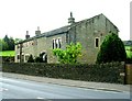
8
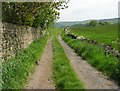
Stanley Lane
Part of footpath Elland no. 63, running eastwards from Stainland Road.
Image: © Betty Longbottom
Taken: 24 May 2008
0.10 miles