
IMAGES TAKEN NEAR TO
Mill Lane, HALIFAX, HX4 9FE
Introduction
This page details the photographs taken nearby to Mill Lane, HX4 9FE by members of the Geograph project.
The Geograph project started in 2005 with the aim of publishing, organising and preserving representative images for every square kilometre of Great Britain, Ireland and the Isle of Man.

There are currently over 7.5m images from over14,400 individuals and you can help contribute to the project by visiting https://www.geograph.org.uk
Image Map
Images are licensed for reuse under creativecommons.org/licenses/by-sa/2.0
Notes
- Clicking on the map will re-center to the selected point.
- The higher the marker number, the further away the image location is from the centre of the postcode.
Image Listing (113 Images Found)
Images are licensed for reuse under creativecommons.org/licenses/by-sa/2.0
Image
Details
Distance

2
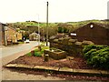
The 'Holy Well', Station Road, Holywell Green
This is unlikely to be the site of the original holy well. The datestone in the centre states that it was improved in 1843. T here is no water now, although I didn't look over the wall. It is listed, Grade II.
Image: © Humphrey Bolton
Taken: 8 Apr 2022
0.05 miles
3
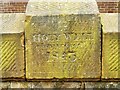
Datestone on the 'Holy Well', Station Road, Holywell Green
See Image] for a view of the 'well'.
Image: © Humphrey Bolton
Taken: 8 Apr 2022
0.05 miles
4
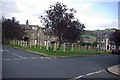
Cross Street green
This little fenced off area really caught my eye. The 4 Copper Beech trees,the benches and the old fashioned metal fencing around this grassy area provide a pleasing open aspect for the residents of Cross Street. It looks in keeping with the area. It could all so easily contain yet another house. I know that there is already a photograph of this location, but it really appeals to me.
Image: © Alan Gerrard
Taken: 24 Oct 2008
0.08 miles
5
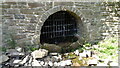
Restored Well
In Shaw Park, with an iron grill marked SPRG 2014 presumably a restoration date.
This well has much more character than the official Holy Well on Station Road
Image: © Kevin Waterhouse
Taken: 27 Jul 2016
0.09 miles
6
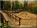
Footbridge over wetland in Shaw Park, Holywell Green
This is a viewing platform for people to watch for wildlife.
Image: © Humphrey Bolton
Taken: 8 Apr 2022
0.09 miles
7
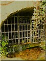
Well in Shaw Park, Holywell Green
This well was restored in 2014. It is probably the 'drippng well' made as part of the landscaping of the park, c.1870, for Samuel Shaw.
Image: © Humphrey Bolton
Taken: 8 Apr 2022
0.09 miles
8
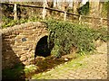
Well in Shaw Park, Holywell Green
Not the 'Holy Well', but one made as part of the landscaping of the park c,1870. See Image] for a close view.
Image: © Humphrey Bolton
Taken: 8 Apr 2022
0.09 miles
9
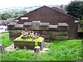
Holy Well, Holywell Green, Stainland
The inscription reads 'Holy Well improved 1843', but there does not seem to be a well now, only a trough with plants in it. St Helen's Well was some distance away at Helen Hill Farm along Jagger Green Lane.
Image: © Humphrey Bolton
Taken: 27 Sep 2006
0.10 miles
10
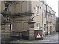
Holywell House, Station Road, Holywell Green, Stainland
The garden front of the building on the other side looks more conventional. This side looks strange; There is some very fine ashlar stonework, mainly plain but with a busy design below the first-floor window. To the right an elaborate ashlar centre, with very plain walls and windows each side. The house was built by a mill-owner and has more recently been a care home.
Image: © Humphrey Bolton
Taken: 27 Sep 2006
0.10 miles