IMAGES TAKEN NEAR TO
West View, HALIFAX, HX4 9EW
Introduction
This page details the photographs taken nearby to West View, HX4 9EW by members of the Geograph project.
The Geograph project started in 2005 with the aim of publishing, organising and preserving representative images for every square kilometre of Great Britain, Ireland and the Isle of Man.

There are currently over 7.5m images from over14,400 individuals and you can help contribute to the project by visiting https://www.geograph.org.uk
Image Map (Loading...)


Getting Data...Please wait
Leaflet Map data © OpenStreetMap
Images are licensed for reuse under creativecommons.org/licenses/by-sa/2.0
Notes
- Clicking on the map will re-center to the selected point.
- The higher the marker number, the further away the image location is from the centre of the postcode.
Image Listing (62 Images Found)
Images are licensed for reuse under creativecommons.org/licenses/by-sa/2.0
Image
Details
Distance
1
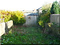
Church Lane, Stainland, blocked by fence and shed
Church Lane is an ancient highway and an unadopted street, so it was an unpleasant surprise to find it completely blocked by a high fence with what looks like a shed behind it.
Image: © Humphrey Bolton
Taken: 7 Nov 2013
0.03 miles
2
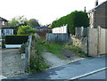
Church Lane, Stainland
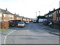
This is the eastern end of the part of the lane that runs parallel to West View. You can see the other side of the blockage shown in Image
Image: © Humphrey Bolton
Taken: 7 Nov 2013
0.04 miles
4
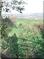
Church Lane east of West View
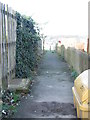
Although originally a lane, it has become a footpath (Elland FP86); however it should perhaps be a bridleway as many of the people travelling between Bradley Hall and Stainland village would surely have been on horseback.
Image: © Humphrey Bolton
Taken: 7 Nov 2013
0.05 miles
7
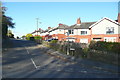
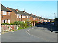
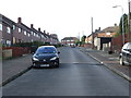
West View - viewed from Church Lane
Image: © Betty Longbottom
Taken: 2 Dec 2014
0.08 miles
9
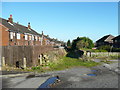
Church Lane, Stainland
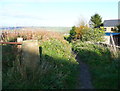
This is the old road from Stainland village to Bradley Hall, shown on the 1850 OS map as 'Bradley Lane' and shown earlier on Myers's map of 1835. It is an unadopted street, but despite its 'pedigree' is not classed as a public right-of-way apart from what is implied by being on the street list. An application was made in 2005 for it to be classed as a public bridleway.
Image: © Humphrey Bolton
Taken: 7 Nov 2013
0.08 miles