IMAGES TAKEN NEAR TO
Blackbrook Way, HALIFAX, HX4 8ED
Introduction
This page details the photographs taken nearby to Blackbrook Way, HX4 8ED by members of the Geograph project.
The Geograph project started in 2005 with the aim of publishing, organising and preserving representative images for every square kilometre of Great Britain, Ireland and the Isle of Man.

There are currently over 7.5m images from over14,400 individuals and you can help contribute to the project by visiting https://www.geograph.org.uk
Image Map (Loading...)


Getting Data...Please wait
Leaflet Map data © OpenStreetMap
Images are licensed for reuse under creativecommons.org/licenses/by-sa/2.0
Notes
- Clicking on the map will re-center to the selected point.
- The higher the marker number, the further away the image location is from the centre of the postcode.
Image Listing (153 Images Found)
Images are licensed for reuse under creativecommons.org/licenses/by-sa/2.0
Image
Details
Distance
1
Stainland Road Medical Centre - Stainland Road
Image: © Betty Longbottom
Taken: 30 Nov 2013
0.02 miles
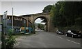
3
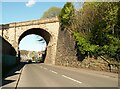
Railway bridge over Stainland Road, Greetland
This carried the branch line to Holywell Green, now disused.
Image: © Humphrey Bolton
Taken: 22 Apr 2022
0.04 miles
4
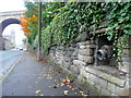
Hose connection, Stainland Road
This is opposite a square open water tank, shown on maps at the top of the retaining wall. It would seem to have been a source of water for fire engines in case of a fire in the local mills.
Image: © Humphrey Bolton
Taken: 3 Oct 2013
0.04 miles
5
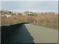
Cycle route on the Greetland Viaduct
I was surprised at the broad expanse of tarmac, but I suppose that it makes it more difficult for trees and bushes to establish themselves and damage the structure.
Image: © Humphrey Bolton
Taken: 10 Feb 2015
0.05 miles
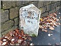
6
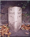
Old Milestone by the B6112, Stainland Road, Elland
Milestone by the B6112, in parish of Elland (Calderdale District), Stainland Road, 200m West of railway bridge, opposite lamppost LP56, back to wall.
Inscription reads:-
: TO / STAINLAND / 1 MILE : : TO / HALIFAX / 3 MILES :
Grade II listed.
List Entry Number: 1184999 https://historicengland.org.uk/listing/the-list/list-entry/1184999
Milestone Society National ID: YW_HAOU03
Image: © Milestone Society
Taken: Unknown
0.05 miles
7
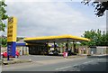
Jet Filling Station - Stainland Road, Greetland
Image: © Betty Longbottom
Taken: 21 May 2008
0.05 miles
8
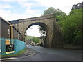
Disused railway bridge over Stainland Road, West vale
Image: © John Slater
Taken: 9 May 2014
0.05 miles
9
Disused Railway Bridge over the B6112, Stainland Road
Once carried the branch line to Holywell Green
Image: © Chris Heaton
Taken: 16 Sep 2023
0.05 miles
10
Old milestone
This old stone is on the B6112 Stainland Road, just west of the railway bridge, southwards from Elland towards New Hey Road near junction 23 on the M62 at Outlane. The righthand face is inscribed HALIFAX 3 MILES. This photograph taken in 2020 shows how the paint on the stone has deteriorated. It is Grade II listed 338535.
Image: © Robert Glover
Taken: 15 Nov 2020
0.05 miles