IMAGES TAKEN NEAR TO
Ravenstone Drive, HALIFAX, HX4 8DU
Introduction
This page details the photographs taken nearby to Ravenstone Drive, HX4 8DU by members of the Geograph project.
The Geograph project started in 2005 with the aim of publishing, organising and preserving representative images for every square kilometre of Great Britain, Ireland and the Isle of Man.

There are currently over 7.5m images from over14,400 individuals and you can help contribute to the project by visiting https://www.geograph.org.uk
Image Map (Loading...)


Getting Data...Please wait
Leaflet Map data © OpenStreetMap
Images are licensed for reuse under creativecommons.org/licenses/by-sa/2.0
Notes
- Clicking on the map will re-center to the selected point.
- The higher the marker number, the further away the image location is from the centre of the postcode.
Image Listing (127 Images Found)
Images are licensed for reuse under creativecommons.org/licenses/by-sa/2.0
Image
Details
Distance
3
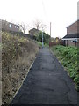
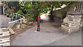
Entrance to cycleway off Green Lane, West Vale
This cycleway crosses the valley on the disused railway viaduct and goes to Saddleworth Road and Rochdale Road. The route to Saddleworth Road was opened in October 2014; the route onwards to Rochdale Road had already been constructed.
Image: © Humphrey Bolton
Taken: 10 Feb 2015
0.05 miles
4
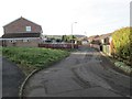
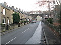
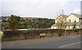
Ravenstone Drive - viewed from Hullenedge Lane
Image: © Betty Longbottom
Taken: 30 Nov 2013
0.06 miles
5
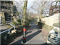
Cycle path from Green Lane, West Vale, towards the West Vale Viaduct
Part of the former line of the North Dean (Stainland) Branch railway has been turned into the West Vale Greenway. The modern path towards the viaduct runs along one side of the former railway formation, now occupied by dwellings.
Image: © Phil Champion
Taken: 31 Jul 2018
0.07 miles
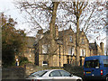
8
Stainland Road Health Centre, Greetland
These new large health centres seem to be springing up in many urban and suburban townships.
Image: © Humphrey Bolton
Taken: 15 Oct 2007
0.08 miles
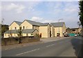
9
Last remains of Ing Wood Mill, Stainland Road, Greetland
The new health centre is built on part of the site of Ing Wood Mill (Worsted), and next to it the bottom part of a wall of one of the mill buildings has been left as a boundary wall, displaying the tops of the basement windows.
Image: © Humphrey Bolton
Taken: 15 Oct 2007
0.08 miles
10
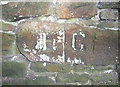
Boundary Stone, Hullen Edge Lane
E for Elland and G for Greetland, made after Greetland became a separate local authority, perhaps when the Urban Districts were created in 1893.
Image: © Humphrey Bolton
Taken: 3 Oct 2013
0.09 miles