IMAGES TAKEN NEAR TO
Greenroyd, HALIFAX, HX4 8DT
Introduction
This page details the photographs taken nearby to Greenroyd, HX4 8DT by members of the Geograph project.
The Geograph project started in 2005 with the aim of publishing, organising and preserving representative images for every square kilometre of Great Britain, Ireland and the Isle of Man.

There are currently over 7.5m images from over14,400 individuals and you can help contribute to the project by visiting https://www.geograph.org.uk
Image Map
Images are licensed for reuse under creativecommons.org/licenses/by-sa/2.0
Notes
- Clicking on the map will re-center to the selected point.
- The higher the marker number, the further away the image location is from the centre of the postcode.
Image Listing (100 Images Found)
Images are licensed for reuse under creativecommons.org/licenses/by-sa/2.0
Image
Details
Distance
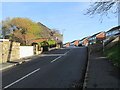
2
Stainland Road Health Centre, Greetland
These new large health centres seem to be springing up in many urban and suburban townships.
Image: © Humphrey Bolton
Taken: 15 Oct 2007
0.06 miles
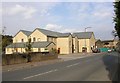
3
Last remains of Ing Wood Mill, Stainland Road, Greetland
The new health centre is built on part of the site of Ing Wood Mill (Worsted), and next to it the bottom part of a wall of one of the mill buildings has been left as a boundary wall, displaying the tops of the basement windows.
Image: © Humphrey Bolton
Taken: 15 Oct 2007
0.06 miles
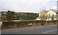
4
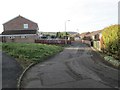
Route of former railway, West Vale
This was the Lancashire and Yorkshire Railway's Stainland Branch. The goods station was on the left, now redeveloped for housing. However the railway itself is now a grassy strip, with trees.
Image: © Humphrey Bolton
Taken: 7 Nov 2013
0.06 miles
9
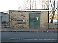
Electricity Substation No 2789 - Stainland Road
Image: © Betty Longbottom
Taken: 30 Nov 2013
0.09 miles
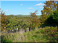
10
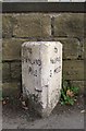
Milestone, Stainland Road, Greetland
This road was built as a turnpike road c.1825, and still has its original milestones whilst on most roads they were replaced by the standard West Riding cast-iron ones. This road was evidently considered to be of minor importance, as it only became a 'B' road rather than an 'A' road.
Image: © Humphrey Bolton
Taken: 15 Oct 2007
0.09 miles