IMAGES TAKEN NEAR TO
Stainland Road, HALIFAX, HX4 8BQ
Introduction
This page details the photographs taken nearby to Stainland Road, HX4 8BQ by members of the Geograph project.
The Geograph project started in 2005 with the aim of publishing, organising and preserving representative images for every square kilometre of Great Britain, Ireland and the Isle of Man.

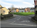
There are currently over 7.5m images from over14,400 individuals and you can help contribute to the project by visiting https://www.geograph.org.uk
Image Map
Images are licensed for reuse under creativecommons.org/licenses/by-sa/2.0
Notes
- Clicking on the map will re-center to the selected point.
- The higher the marker number, the further away the image location is from the centre of the postcode.
Image Listing (104 Images Found)
Images are licensed for reuse under creativecommons.org/licenses/by-sa/2.0
Image
Details
Distance
2
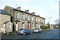
Terrace Houses at Little Bradley, Stainland Road, Greetland
These are shown on the 1893 1:2500 map as a block of eight back-to-backs. The modern map shows that there is still one end pair back-to-back and the others converted to 'throughs'.
Image: © Humphrey Bolton
Taken: 16 Jan 2014
0.02 miles
5
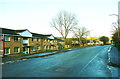
Flats on the Little Bradley Estate, Stainland Road, West Vale
In the distance is the bright yellow Jet filling station.
Image: © Humphrey Bolton
Taken: 9 Jan 2014
0.03 miles
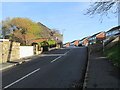
6
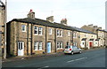
Terrace houses, Stainland Road, Greetland
Here there is a row of three houses shown on the 1893 1:2500 map as back-to-backs, but now 'throughs'. The three modern houses replaced older ones.
Image: © Humphrey Bolton
Taken: 16 Jan 2014
0.03 miles
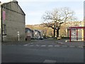
7
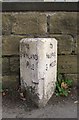
Milestone, Stainland Road, Greetland
This road was built as a turnpike road c.1825, and still has its original milestones whilst on most roads they were replaced by the standard West Riding cast-iron ones. This road was evidently considered to be of minor importance, as it only became a 'B' road rather than an 'A' road.
Image: © Humphrey Bolton
Taken: 15 Oct 2007
0.04 miles
8
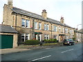
Terrace houses, Stainland Road, Greetland
This is the first block on the left as you enter West Vale from the south. The houses are not on the 1893 1:2500 map, and are shown on the 1907 1:2500 map as back-to-backs. They are now shown as five 'throughs'.
Image: © Humphrey Bolton
Taken: 16 Jan 2014
0.05 miles
9
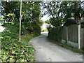
Lane from the site of Lower Bradley Mill to Stainland Road
This is Elland Footpath 37.
Image: © Humphrey Bolton
Taken: 26 Sep 2013
0.06 miles
10
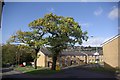
Oak trees
It is good to see that these oak trees have survived; they sit well amongst the modern housing.
Image: © Alan Gerrard
Taken: 17 Nov 2008
0.06 miles