IMAGES TAKEN NEAR TO
Ringstone, HALIFAX, HX4 0EU
Introduction
This page details the photographs taken nearby to Ringstone, HX4 0EU by members of the Geograph project.
The Geograph project started in 2005 with the aim of publishing, organising and preserving representative images for every square kilometre of Great Britain, Ireland and the Isle of Man.

There are currently over 7.5m images from over14,400 individuals and you can help contribute to the project by visiting https://www.geograph.org.uk
Image Map
Images are licensed for reuse under creativecommons.org/licenses/by-sa/2.0
Notes
- Clicking on the map will re-center to the selected point.
- The higher the marker number, the further away the image location is from the centre of the postcode.
Image Listing (7 Images Found)
Images are licensed for reuse under creativecommons.org/licenses/by-sa/2.0
Image
Details
Distance
3
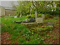
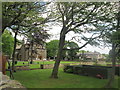
Methodist burial ground. Krumlin, Barkisland
Image: © Humphrey Bolton
Taken: 6 May 2023
0.08 miles
4
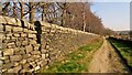
Walling for Krumlin Hall
On the Causeway
Image: © Kevin Waterhouse
Taken: 26 Mar 2022
0.17 miles
6
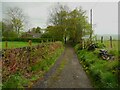
Lane approaching Jumble Head Farm, Barkisland
This is Footpath 103/5, which continues as a track after passing the farm.
Image: © Humphrey Bolton
Taken: 6 May 2023
0.22 miles
7
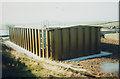
Krumlin service reservoir
A twin-compartment steel tank erected in 1990 for Yorkshire Water to act as a service reservoir for Krumlin and Barkisland and as strategic storage for the Sowerby Bridge area in the event of problems with the supply from Halifax. The contractor was Booth Engineering of Bolton.
Image: © Stephen Craven
Taken: Unknown
0.24 miles