IMAGES TAKEN NEAR TO
Barkisland, HALIFAX, HX4 0ET
Introduction
This page details the photographs taken nearby to HX4 0ET by members of the Geograph project.
The Geograph project started in 2005 with the aim of publishing, organising and preserving representative images for every square kilometre of Great Britain, Ireland and the Isle of Man.

There are currently over 7.5m images from over14,400 individuals and you can help contribute to the project by visiting https://www.geograph.org.uk
Image Map
Images are licensed for reuse under creativecommons.org/licenses/by-sa/2.0
Notes
- Clicking on the map will re-center to the selected point.
- The higher the marker number, the further away the image location is from the centre of the postcode.
Image Listing (20 Images Found)
Images are licensed for reuse under creativecommons.org/licenses/by-sa/2.0
Image
Details
Distance
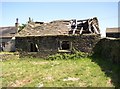
1
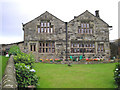
Wormald
A typical mid 17th Century Pennine farmhouse.
Image: © John Illingworth
Taken: 11 Jul 2007
0.02 miles
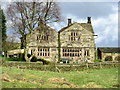
2
Wormald Farm
Pennine farmhouse located on Bottomley Lane in Barkisland, dating back to 1693.
Image: © Chris Heaton
Taken: 16 Sep 2023
0.03 miles
4
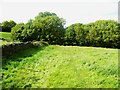
Ripponden Footpath 89/8 approaching Bottomley Lane, Barkisland
Image: © Humphrey Bolton
Taken: 13 May 2022
0.10 miles
5
Outbuilding to Calf Hey Farm, Bottomley Lane, Barkisland
This is listed Grade 2 as an 'unusual and interesting building' of indeterminate use, but possibly a detached kitchen (or a small cottage?). The mullioned window on the left is what caught the eye; the east side has a wooden door frame with depressed Tudor arched lintel. The listing gives the period as early 17C. The building material is coursed rubble, with a stone-slate roof. Inside there are two rooms, one with a segmental-arched fireplace.
Image: © Humphrey Bolton
Taken: 2 Jun 2006
0.11 miles
6
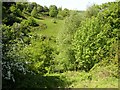
Bottomley Clough, Barkisland
Clough is the local name for a narrow steep-sided valley. This photo shows a view across it near its head, although it continues as a small valley right up to Krumlin in SE0518. There is a public footpath across the valley here, although it is evidently little-used as there is no sign of a path.
Image: © Humphrey Bolton
Taken: 2 Jun 2006
0.11 miles
7
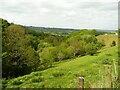
View of Bottomley Clough from Bottomley Lane, Barkisland
Much more woodland than is shown on the map.
Image: © Humphrey Bolton
Taken: 13 May 2022
0.11 miles
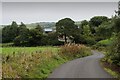
8
Bottomley Lane, Barkisland
Calf Hey is in the distance.
Image: © Humphrey Bolton
Taken: 13 May 2022
0.12 miles
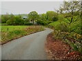
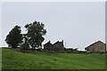
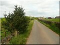
10
Bottomley Lane approaching Handcroft Farm
Narrow lane descending towards the valley of Black Brook, in the scattered community of Barkisland
Image: © Chris Heaton
Taken: 16 Sep 2023
0.16 miles