IMAGES TAKEN NEAR TO
Barkisland, HALIFAX, HX4 0EH
Introduction
This page details the photographs taken nearby to HX4 0EH by members of the Geograph project.
The Geograph project started in 2005 with the aim of publishing, organising and preserving representative images for every square kilometre of Great Britain, Ireland and the Isle of Man.

There are currently over 7.5m images from over14,400 individuals and you can help contribute to the project by visiting https://www.geograph.org.uk
Image Map (Loading...)


Getting Data...Please wait
Leaflet Map data © OpenStreetMap
Images are licensed for reuse under creativecommons.org/licenses/by-sa/2.0
Notes
- Clicking on the map will re-center to the selected point.
- The higher the marker number, the further away the image location is from the centre of the postcode.
Image Listing (24 Images Found)
Images are licensed for reuse under creativecommons.org/licenses/by-sa/2.0
Image
Details
Distance
1
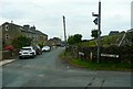
Sky sign, Scammonden Road, Barkisland
Presumably there is a photographer down the lane to the left.
Image: © Humphrey Bolton
Taken: 28 Jul 2022
0.02 miles
2
Footpath 109/1 leaving Scammonden Road, Barkisland
The path is on a farm access lane at first.
Image: © Humphrey Bolton
Taken: 28 Jul 2022
0.04 miles
3
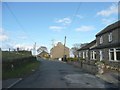
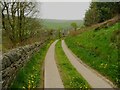
Scammonden Road, Krumlin, Barkisland
In this area there are houses dotted along the roads, only occasionally forming a cluster big enough to call a hamlet.
Image: © Humphrey Bolton
Taken: 7 Mar 2008
0.08 miles
4
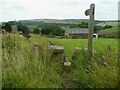
Stile and signpost on Footpath 105/2, Barkisland
This is at Scammonden Road.
Image: © Humphrey Bolton
Taken: 28 Jul 2022
0.11 miles
5
Footpath 108/2 on access lane to Wood Head, Barkisland
Image: © Humphrey Bolton
Taken: 28 Jul 2022
0.12 miles
6
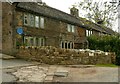
Lower Woodhead, Barkisland
This building is listed, Grade II. The half to the right was built in the late 17C, and on the left in 1736. The blue plaque was placed here by Ripponden Parish Council for John Stansfield, horologist, 1706-1730, who lived and made fine longcase clocks here. Footpath 108/4 passes in the foreground. See Image] for the plaque.
Image: © Humphrey Bolton
Taken: 6 May 2023
0.13 miles
7
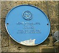
Blue plaque at Lower Woodhead, Barkisland
See Image] for the building.
Image: © Humphrey Bolton
Taken: 6 May 2023
0.13 miles
8
Driveway to Lower Wood Head, Barkisland
This is Footpath 108/2.
Image: © Humphrey Bolton
Taken: 6 May 2023
0.13 miles
9
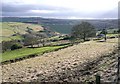
View towards Lower Nook, Krumlin, Barkisland
This is taken from the driveway (a public footpath) to Lower Nook. The face of Scammonden Dam is in the distance, and the access road to the lower side of the dam can be seen descending the far hillside in a cutting.
Image: © Humphrey Bolton
Taken: 7 Mar 2008
0.13 miles
10
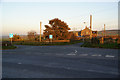
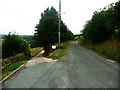
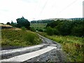
Meeting of roads
The major road, the nearest one, is the B6114. The road to the left is Moor Field Road, but the lane opposite doesn't seem to have a name.
Image: © Bill Boaden
Taken: 7 Oct 2010
0.14 miles