
IMAGES TAKEN NEAR TO
Lower Top Of Hill, HALIFAX, HX4 0EB
Introduction
This page details the photographs taken nearby to Lower Top Of Hill, HX4 0EB by members of the Geograph project.
The Geograph project started in 2005 with the aim of publishing, organising and preserving representative images for every square kilometre of Great Britain, Ireland and the Isle of Man.

There are currently over 7.5m images from over14,400 individuals and you can help contribute to the project by visiting https://www.geograph.org.uk
Image Map
Images are licensed for reuse under creativecommons.org/licenses/by-sa/2.0
Notes
- Clicking on the map will re-center to the selected point.
- The higher the marker number, the further away the image location is from the centre of the postcode.
Image Listing (58 Images Found)
Images are licensed for reuse under creativecommons.org/licenses/by-sa/2.0
Image
Details
Distance

2

An old gatepost in the woods, Scammonden Water
This gatepost can be seen in context in Image
Image: © habiloid
Taken: 5 Jun 2022
0.09 miles
3

An old gatepost in the woods, Scammonden Water
A close-up of this gatepost can be seen in Image
Image: © habiloid
Taken: 5 Jun 2022
0.09 miles
4

Path from Scammonden Dam towards the B6114
The bridge in the distance carries the B6114 over the M62.
Image: © habiloid
Taken: 5 Jun 2022
0.10 miles


7
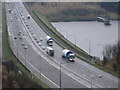
Turbine Tower Delivery on the M62 at Scammonden
Two tower sections en route to Scout Moor for turbine No 5 head west along the M62 at Scammonden Dam.
Image
Image
Image
Image
Image
Image
Turbine details: Tower Height: 60m
Blade Length: 40m Total Max Height: 100m
Manufacturer: Nordex
Model: N80
Scout Moor Wind Farm Construction Picture Gallery http://www.geograph.org.uk/gallery/scoutmoor_wind_farm_construction_6568
Image: © Paul Anderson
Taken: 12 Apr 2008
0.11 miles
8
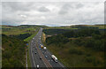
The M62 seen from Scammonden Bridge
The M62 can be seen crossing Scammonden Dam from Scammonden Bridge which carries Saddleworth Road (B6114) across it.
Image: © habiloid
Taken: 29 Aug 2022
0.11 miles
9
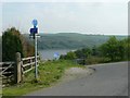
National Cycle Route signpost, Scammonden
This is on Route 68, pointing the way across Scammonden Dam en-route to Holmfirth.
Image: © Humphrey Bolton
Taken: 12 May 2008
0.13 miles
10
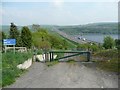
NCN Route 68, Scammonden
Looking down to Scammonden Dam. The cycle path does not go along the visible path, which would have views down the valley, but instead goes under the M62 and on a path on the reservoir side of the dam. In the foreground one of those terrible A-frames, not wide enough for the handlebars, nor for cyclists of ample proportions.
Image: © Humphrey Bolton
Taken: 12 May 2008
0.13 miles