IMAGES TAKEN NEAR TO
Lower Gilbert Fields, HALIFAX, HX4 0BX
Introduction
This page details the photographs taken nearby to Lower Gilbert Fields, HX4 0BX by members of the Geograph project.
The Geograph project started in 2005 with the aim of publishing, organising and preserving representative images for every square kilometre of Great Britain, Ireland and the Isle of Man.

There are currently over 7.5m images from over14,400 individuals and you can help contribute to the project by visiting https://www.geograph.org.uk
Image Map (Loading...)


Getting Data...Please wait
Leaflet Map data © OpenStreetMap
Images are licensed for reuse under creativecommons.org/licenses/by-sa/2.0
Notes
- Clicking on the map will re-center to the selected point.
- The higher the marker number, the further away the image location is from the centre of the postcode.
Image Listing (71 Images Found)
Images are licensed for reuse under creativecommons.org/licenses/by-sa/2.0
Image
Details
Distance
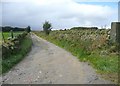
1
Footpath from Barsey Green Lane to Greetland Road
This is Ripponden Footpath 71, and goes up past the converted Methodist chapel.
Image: © Humphrey Bolton
Taken: 7 Apr 2013
0.00 miles
2

Driveway to Spring Hill, Greetland
But what is that tall slender stone on the left? I went to investigate: see Image
Image: © Humphrey Bolton
Taken: 2 Oct 2008
0.04 miles
3

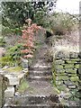
Footpath off Barsey Green Lane
This is Ripponden Footpath 72 as it leaves Barsey Green Lane, passing through a garden.
Image: © Humphrey Bolton
Taken: 7 Apr 2013
0.05 miles
4
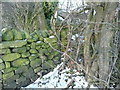
Wall across Ripponden FP72 at Greetland Wall Nook
This footpath is occupied by trees as it follows the parish boundary wall up from Bowers lane at Shaw Head, but you can walk up the field edge alongside it. However at the top of the field you are faced with this wall, with no sign of a stile. If you climb over it you are in someone's garden, and you would have to find a way through it to meet Elland FP49. No doubt the owner would deny the existence of the path, but it is there on the council's rights-of-way map and is captioned 'Foot Path' on the 1932 1:2500 map.
Image: © Humphrey Bolton
Taken: 19 Jan 2015
0.05 miles
5

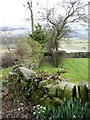
The western end of Elland Footpath 49
As it leaves the garden of the house seen to the left, the path goes across the parish boundary. The snow is typical of the drifts that have been taking ages to melt in the continuing winter temperstures.
Image: © Humphrey Bolton
Taken: 7 Apr 2013
0.05 miles
6
Blocked footpath off Barsey Green Lane
This is Ripponden Footpath 72, which is caption 'path' or FP on OS maps old and new. It runs alongside the parish boundary down to Shaw Head. A short section is preserved in this garden, but has walls built across it. Beyond the garden I suspect that it will have become overgrown.
Image: © Humphrey Bolton
Taken: 7 Apr 2013
0.05 miles
7
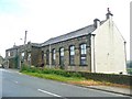
Former Chapel, Greetland Road, Barkisland
The denomination is not shown on the old six-inch maps and has been erased from the plaque over the door.
Image: © Humphrey Bolton
Taken: 2 Oct 2008
0.07 miles
8
Garden Lane, Barkisland
The wall on the right (north side) of lane is the boundary between Barkisland and Greetland. The lane is Ripponden Bridleway 68 (although the on-linne rights-of-way map captions it Elland Bridleway 68, but Ripponden Bridleway 68 further to the west. It is in barkisland, which was in Ripponden UDC).
Image: © Humphrey Bolton
Taken: 2 Oct 2008
0.07 miles
9
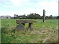
Cromlech and standing stone, Greetland
I doubt these are prehistoric, else they would be on the OS maps. I suspect that they are made of stones from the quarry nearby.
Image: © Humphrey Bolton
Taken: 2 Oct 2008
0.07 miles
10
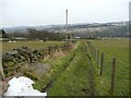
Western end of Bowers Lane, Barkisland
This is the eastern part of Ripponden Bridleway 73, and goes from Barsey Green Lane to Saddleworth Lane.
Image: © Humphrey Bolton
Taken: 7 Apr 2013
0.08 miles