IMAGES TAKEN NEAR TO
School Lane, HALIFAX, HX3 9TL
Introduction
This page details the photographs taken nearby to School Lane, HX3 9TL by members of the Geograph project.
The Geograph project started in 2005 with the aim of publishing, organising and preserving representative images for every square kilometre of Great Britain, Ireland and the Isle of Man.

There are currently over 7.5m images from over14,400 individuals and you can help contribute to the project by visiting https://www.geograph.org.uk
Image Map
Images are licensed for reuse under creativecommons.org/licenses/by-sa/2.0
Notes
- Clicking on the map will re-center to the selected point.
- The higher the marker number, the further away the image location is from the centre of the postcode.
Image Listing (113 Images Found)
Images are licensed for reuse under creativecommons.org/licenses/by-sa/2.0
Image
Details
Distance

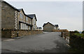
3
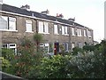
Lud Hill Top, School Lane, Southowram
These terrace houses have pleasant front gardens.
Image: © Humphrey Bolton
Taken: 23 Sep 2006
0.03 miles

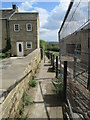
6
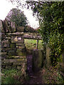
Stile on Footpath 12.29.1, Southowram
This stile has a very fat round post to squeeze past. The waymark is for the Calderdale Way.
Image: © Humphrey Bolton
Taken: 21 Jan 2021
0.06 miles

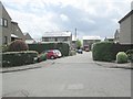
8
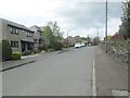
Grange Heights - looking towards Ashday Lane
Image: © Betty Longbottom
Taken: 14 May 2013
0.07 miles
9

Southowram Methodist Chapel Graveyard - Chapel Lane
Image: © Betty Longbottom
Taken: 18 Oct 2008
0.07 miles