IMAGES TAKEN NEAR TO
Le Mar View, HALIFAX, HX3 9NW
Introduction
This page details the photographs taken nearby to Le Mar View, HX3 9NW by members of the Geograph project.
The Geograph project started in 2005 with the aim of publishing, organising and preserving representative images for every square kilometre of Great Britain, Ireland and the Isle of Man.

There are currently over 7.5m images from over14,400 individuals and you can help contribute to the project by visiting https://www.geograph.org.uk
Image Map
Images are licensed for reuse under creativecommons.org/licenses/by-sa/2.0
Notes
- Clicking on the map will re-center to the selected point.
- The higher the marker number, the further away the image location is from the centre of the postcode.
Image Listing (73 Images Found)
Images are licensed for reuse under creativecommons.org/licenses/by-sa/2.0
Image
Details
Distance
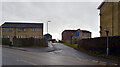
4
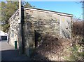
Electricity Substation No 1606 - Marsh Lane
Image: © Betty Longbottom
Taken: 2 Mar 2013
0.05 miles
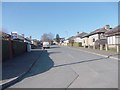
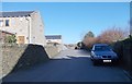
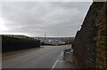
5
The Crescent - looking towards Long Lane
Image: © Betty Longbottom
Taken: 2 Mar 2013
0.05 miles
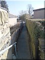
7
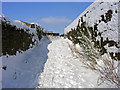
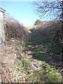
Green Lane
Photo taken near the start of the track at Bank Top. This part of green lane runs between high dry stone walls.
Image: © Phil Champion
Taken: 3 Feb 2009
0.08 miles