IMAGES TAKEN NEAR TO
Aysgarth Avenue, HALIFAX, HX3 8UZ
Introduction
This page details the photographs taken nearby to Aysgarth Avenue, HX3 8UZ by members of the Geograph project.
The Geograph project started in 2005 with the aim of publishing, organising and preserving representative images for every square kilometre of Great Britain, Ireland and the Isle of Man.

There are currently over 7.5m images from over14,400 individuals and you can help contribute to the project by visiting https://www.geograph.org.uk
Image Map
Images are licensed for reuse under creativecommons.org/licenses/by-sa/2.0
Notes
- Clicking on the map will re-center to the selected point.
- The higher the marker number, the further away the image location is from the centre of the postcode.
Image Listing (70 Images Found)
Images are licensed for reuse under creativecommons.org/licenses/by-sa/2.0
Image
Details
Distance
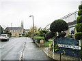
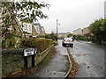
4
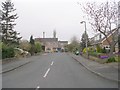
Kenilworth Drive - Smith House Lane
Image: © Betty Longbottom
Taken: 15 Apr 2009
0.05 miles
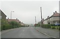
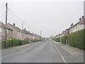
5
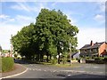
Trees at Smith House Lane, Lightcliffe, Hipperholme
The town-planners have done well here, as a row of trees has been preserved amongst suburbia.
Image: © Humphrey Bolton
Taken: 22 Aug 2005
0.06 miles