IMAGES TAKEN NEAR TO
East View, HALIFAX, HX3 8TR
Introduction
This page details the photographs taken nearby to East View, HX3 8TR by members of the Geograph project.
The Geograph project started in 2005 with the aim of publishing, organising and preserving representative images for every square kilometre of Great Britain, Ireland and the Isle of Man.

There are currently over 7.5m images from over14,400 individuals and you can help contribute to the project by visiting https://www.geograph.org.uk
Image Map
Images are licensed for reuse under creativecommons.org/licenses/by-sa/2.0
Notes
- Clicking on the map will re-center to the selected point.
- The higher the marker number, the further away the image location is from the centre of the postcode.
Image Listing (76 Images Found)
Images are licensed for reuse under creativecommons.org/licenses/by-sa/2.0
Image
Details
Distance
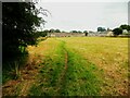
1
View from Till Carr Lane, Lightcliffe, Hipperholme
This view is across the back of the built up area alongside Wakefield Road. The terrace of houses in the distance is Ripley Street.
Image: © Humphrey Bolton
Taken: 2 Apr 2007
0.02 miles
2
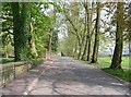
Till Carr Lane - Wakefield Road, Lightcliffe
Image: © Betty Longbottom
Taken: 7 May 2008
0.04 miles
3
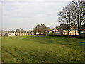
King George's Field - Wakefield Road, Lightcliffe
Image: © Betty Longbottom
Taken: 7 May 2008
0.05 miles
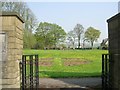
4
Till Carr Lane, Lightcliffe, Hipperholme
This narrow lane was named after Till Carr Farm, and becomes Rookes Lane after it fords Bottom Hall Beck. This is at the southern end of the lane, between the old churchyard on the left and King George V Park on the right.
Image: © Humphrey Bolton
Taken: 2 Apr 2007
0.06 miles
5
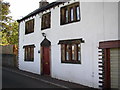
Till Carr Cottage, Till Carr Lane, Lightcliffe
A nice old house, although the white-painted rendering does not seem to go with the 17C mullioned windows.
Image: © Humphrey Bolton
Taken: 22 Aug 2005
0.06 miles
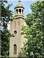
7
Ordnance Survey Rivet with Cut Mark
This rivet and cut mark can be found on Old Church Tower.
For more detail see : http://www.bench-marks.org.uk/bm44011
Image: © Peter Wood
Taken: 15 Jul 2012
0.07 miles
8
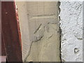
Ordnance Survey Cut Mark
This damaged mark can be found on Till Carr Cottage.
For more detail see : http://www.bench-marks.org.uk/bm44012
Image: © Peter Wood
Taken: 15 Jul 2012
0.07 miles
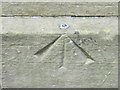
9
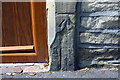
Benchmark on Till Carr Cottage
Ordnance Survey cut mark benchmark described on the Bench Mark Database at www.bench.marks.org.uk/bm44012
Image: © Roger Templeman
Taken: 7 Aug 2018
0.07 miles
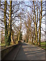
10
Brighouse Footpath 15/4 leaving Till Carr Lane, Lightcliffe
The row of houses in the distance is on Ripley Street.
Image: © Humphrey Bolton
Taken: 27 Aug 2023
0.07 miles