IMAGES TAKEN NEAR TO
Shibden Dene, HX3 8PH
Introduction
This page details the photographs taken nearby to Shibden Dene, HX3 8PH by members of the Geograph project.
The Geograph project started in 2005 with the aim of publishing, organising and preserving representative images for every square kilometre of Great Britain, Ireland and the Isle of Man.

There are currently over 7.5m images from over14,400 individuals and you can help contribute to the project by visiting https://www.geograph.org.uk
Image Map
Images are licensed for reuse under creativecommons.org/licenses/by-sa/2.0
Notes
- Clicking on the map will re-center to the selected point.
- The higher the marker number, the further away the image location is from the centre of the postcode.
Image Listing (99 Images Found)
Images are licensed for reuse under creativecommons.org/licenses/by-sa/2.0
Image
Details
Distance
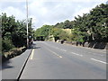
1
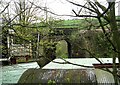
Bridge MRB-25 - Halifax Road, Hipperholme
Image: © Betty Longbottom
Taken: 30 Apr 2008
0.02 miles
3
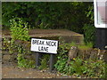
Careful here!
The street sign at the junction of Whitehall Road (A58) and Break Neck Lane
Image: © Michael Steele
Taken: 15 May 2014
0.03 miles
5
Break Neck Lane
Appropriately named!
Image: © Michael Steele
Taken: 15 May 2014
0.04 miles
6
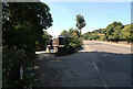
The junction of Break Neck Lane and Leeds Road (A58), Halifax
Image: © habiloid
Taken: 11 Aug 2022
0.04 miles
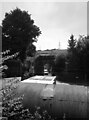
7
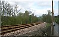
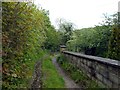
Railway Line - Halifax Road, Hipperholme
Image: © Betty Longbottom
Taken: 30 Apr 2008
0.04 miles
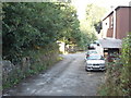
8
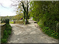
Break Neck Lane, Northowram
The lane keeps right here, the left turn is a private driveway.
Image: © Humphrey Bolton
Taken: 23 Apr 2020
0.04 miles
9
Leeds Road - viewed from Break Neck Lane
Image: © Betty Longbottom
Taken: 19 Sep 2012
0.05 miles
10
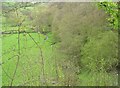
Stream - Halifax Road, Hipperholme
Image: © Betty Longbottom
Taken: 30 Apr 2008
0.05 miles