IMAGES TAKEN NEAR TO
Denholme Gate Road, HALIFAX, HX3 8JR
Introduction
This page details the photographs taken nearby to Denholme Gate Road, HX3 8JR by members of the Geograph project.
The Geograph project started in 2005 with the aim of publishing, organising and preserving representative images for every square kilometre of Great Britain, Ireland and the Isle of Man.

There are currently over 7.5m images from over14,400 individuals and you can help contribute to the project by visiting https://www.geograph.org.uk
Image Map
Images are licensed for reuse under creativecommons.org/licenses/by-sa/2.0
Notes
- Clicking on the map will re-center to the selected point.
- The higher the marker number, the further away the image location is from the centre of the postcode.
Image Listing (32 Images Found)
Images are licensed for reuse under creativecommons.org/licenses/by-sa/2.0
Image
Details
Distance
1
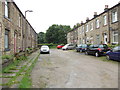
Gaythorne Terrace - off Denholme Gate Road
Image: © Betty Longbottom
Taken: 11 Jun 2012
0.03 miles
2
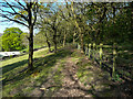
Path at Throstle Nest
This crosses the footpath down from Common Wood. It could be an alternative to the public footpath that passes close to Throstle Nest, but it is not a right-of-way.
Image: © Humphrey Bolton
Taken: 24 Apr 2020
0.05 miles
3
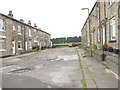
Southfield Terrace - Denholme Gate Road
Image: © Betty Longbottom
Taken: 11 Jun 2012
0.05 miles
5
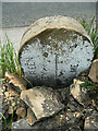
Boundary stone, Denholme Gate Road, Hipperholme
The stone has been reversed against a stone wall but the top of the wall has collapsed allowing sufficient of the inscription to be shown. The stone was probably erected when the Hipperholme Local Board was formed in the 19C. See also Image] for the blank side of the stone facing the road.
Image: © Humphrey Bolton
Taken: 3 Jun 2021
0.05 miles
6
Boundary stone, Brighouse and Denholme Gate Road, Hipperholme
This is where the boundary between Hipperholme UD and Norwood Green & Coley CP crossed the road, having followed the roadside wall from Northedge lane. The stone is similar to other boundary stones in the area, with a rounded top, and I was puzzled as to why it is blank. Then I looked at the back of it and found that it has been turned round. On the back is a vertical line with Norwood Green and Coley on one side and Hipperholme on the other. Only part of the inscription can be seen due to the proximity of the stone wall behind.
Image: © Humphrey Bolton
Taken: 15 Nov 2007
0.05 miles
7
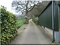
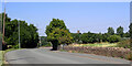
Footpath to Denholme Gate Road (A644) making use of the driveway at Throstle Nest
Looking north-eastward.
Image: © Peter Wood
Taken: 15 Apr 2018
0.06 miles
8
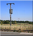
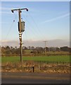
Electricity transmission line and a boundary stone, Denholme Gate Road (A644)
The stone marks the boundary between Coley and Hipperholme. It has been turned around do the inscription faces the wall.
Image: © habiloid
Taken: 11 Aug 2022
0.06 miles
9
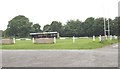
Old Brodleiands RUFC - Denholme Gate Road
Image: © Betty Longbottom
Taken: 11 Jun 2012
0.07 miles