IMAGES TAKEN NEAR TO
Shibden Hall Road, HALIFAX, HX3 7XA
Introduction
This page details the photographs taken nearby to Shibden Hall Road, HX3 7XA by members of the Geograph project.
The Geograph project started in 2005 with the aim of publishing, organising and preserving representative images for every square kilometre of Great Britain, Ireland and the Isle of Man.

There are currently over 7.5m images from over14,400 individuals and you can help contribute to the project by visiting https://www.geograph.org.uk
Image Map
Images are licensed for reuse under creativecommons.org/licenses/by-sa/2.0
Notes
- Clicking on the map will re-center to the selected point.
- The higher the marker number, the further away the image location is from the centre of the postcode.
Image Listing (146 Images Found)
Images are licensed for reuse under creativecommons.org/licenses/by-sa/2.0
Image
Details
Distance
1
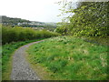
New footpath from Beacon Hill to Shibden Hall
From here the path goes down alongside the boundary of Cunnery Wood to a kissing gate at Shibden Hall Road.
Image: © Humphrey Bolton
Taken: 25 Apr 2017
0.05 miles
2
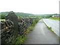
Path from Beacon Hill to Shibden Hall Road, Halifax
Image: © habiloid
Taken: 19 Feb 2021
0.07 miles
3
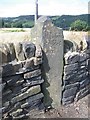
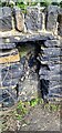
Old Milestone by Shibden Hall Road
Carved stone post by the UC road, in parish of HALIFAX (CALDERDALE District), Shibden Hall Road, near Lister's Road, in dry stone wall near overhead power lines and cutting for railway tunnel, on North side of road. Erected by an unknown authority in the 18th century.
Inscription reads:-
: Bradford / th (?) : : Wakefield / 15 Miles / and ¼ :
Milestone Society National ID: YW_WKBF15.
Image: © C Minto
Taken: 11 Oct 2003
0.07 miles
4
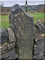
Old milestone on Shibden Hall Road
On Shibden Hall Road north east of Halifax this old stone may have been moved from its original location. Both Wakefield and Bradford are inscribed on it and both are to the east. A more logical site would be near what is now the A56/A649/A644 junction in Hipperholme. There was a Wakefield - Halifax turnpike dating from 1741 that would have passed near the present junction in Hipperholme.
The face of the stone flush with the wall has Bradford inscribed. The rest is hidden by the top stone of the wall.
Image: © Robert Glover
Taken: 17 Nov 2020
0.07 miles
5
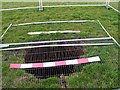
Ancient Mineshaft
This shaft, surrounded by Herras Fencing, is immediately next to Listers Road near to the Shibden Hall Car Park. The warning signs inducate the responsibility of the Coal Authority. Halifax is well outside the areas of the Yorkshire Coalfield mined in the second half of the 20th Century, but there was mining here at the outset of the Industrial Revolution.
Image: © Michael Steele
Taken: 22 Mar 2009
0.07 miles
6
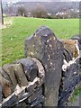
Old Boundary Marker on Shibden Hall Road, Halifax
Boundary Marker inset in a drystone wall on the north side of Shibden Hall Road, Halifax, about 2 metres west of milestone YW_WKBF15. On the former boundary of Southowram and Northowram townships, both parishes from 1866, but without an inscription the stone's function cannot be defined.
Milestone Society National ID: YW_HALI09bm
Image: © W Biswas
Taken: 1 Aug 2023
0.08 miles
7
Milestone Lister's Road
This milestone has been built into the wall so that one of its two engraved faces is partly obscured. Parallel with the road, it recites a distance to Wakefield. The obscured face gives a distance to Bradford. There is no other engraving despite its location near to what was the Halifax to Wakefield turnpike.
Image: © Michael Steele
Taken: 22 Mar 2009
0.08 miles
8
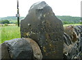
Guide stone, Lister's Road, Halifax
This was presumably at a junction where travellers from Halifax could turn left for Bradford and right for Wakefield. The stone has probably been moved from its original position. Jeffrys's map of 1775 does show this junction, but it is difficult to relate it to the present road layout.
Image: © Humphrey Bolton
Taken: 5 Jun 2017
0.08 miles
9
Lister's Road at the guide stone, Halifax
See Image for a close view.
Image: © Humphrey Bolton
Taken: 5 Jun 2017
0.08 miles
10
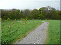
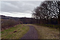
New footpath from Beacon Hill to Shibden hall, Halifax
This path has been designed for wheelchairs, and crosses the field in a big curve to lesson the gradient.
Image: © Humphrey Bolton
Taken: 25 Apr 2017
0.08 miles